America on the Move
John C. Frémont - Exploring Expedition to the Rocky Mountains, 1843
John C. Frémont’s official report on the 1842 expedition he led to the Rocky Mountains reads like a great adventure story. Frémont’s father-in-law, Thomas Hart Benton, a powerful senator from Missouri and strong proponent of western expansion, was a major supporter of the expedition, whose purpose was to survey and map the Oregon Trail to the Rocky Mountains. The senator hoped it would encourage Americans to emigrate and develop commerce along the western trails.
The party that included some twenty Creole and Canadian voyageurs and the legendary Kit Carson, started out just west of the Missouri border, crossed the present-day states of Kansas, Nebraska, and Wyoming, and ascended what the men believed to be the highest peak in the Wind River region of the Rockies. Frémont’s report provided practical information about the geology, botany, and climate of the West that guided future emigrants along the Oregon Trail; it shattered the misconception of the West as the Great American Desert.
Upon his return home to Washington, DC, Frémont dictated much of the report to his wife, Jessie Benton Frémont, a gifted writer. “The horseback life, the sleep in the open air,” she later recalled, “had unfitted Mr. Frémont for the indoor work of writing,” and so she helped him. Distilled from Frémont’s notes and filtered through the artistic sensibilities of his wife, the report is a practical guide, infused with the romance of the western trail.
A Report of an Exploration of the Country Lying between the Missouri River and the Rocky Mountains on the Line of the Kansas and Great Platte Rivers, by John Charles Frémont, March 1, 1843, page 6
These pages recount the party’s fording of the Kansas River near present-day Topeka on June 14, 1842, four days after setting out just west of the Missouri border. After riding and driving the animals across, the party used their inflatable rubber boat to ferry their provisions.
On the seventh and last trip, Frémont describes how the boat capsized spilling carts, boxes, and barrels into the water. Most were recovered; but almost the entire provision of coffee was lost—a loss that would be often and mournfully remembered.
The first nineteen pages of the report, including these, are in the hand of Jessie Benton Frémont.
National Archives, Records of the Office of the Chief of Engineers
Excerpt:
“We reached the ford of the Kansas [River] late in the afternoon . . . I had expected to find the river fordable, but it had been swollen by the late rains, and was sweeping by with an angry current, yellow and turbid . . .”
—From John C. Frémont’s report
.
A Report of an Exploration of the Country Lying between the Missouri River and the Rocky Mountains on the Line of the Kansas and Great Platte Rivers, by John Charles Frémont, March 1, 1843, page 7
These pages recount the party’s fording of the Kansas River near present-day Topeka on June 14, 1842, four days after setting out just west of the Missouri border. After riding and driving the animals across, the party used their inflatable rubber boat to ferry their provisions.
On the seventh and last trip, Frémont describes how the boat capsized spilling carts, boxes, and barrels into the water. Most were recovered; but almost the entire provision of coffee was lost—a loss that would be often and mournfully remembered.
The first nineteen pages of the report, including these, are in the hand of Jessie Benton Frémont.
National Archives, Records of the Office of the Chief of Engineers
Excerpt:
“I put upon the boat the remaining two carts with their accompanying loads. The man at the helm was timid in water, and in his alarm capsized the boat. Carts, barrels, boxes and bales, were in a moment floating down the current, but all the men who were on the shore, jumped into the water, without stopping to think if they could swim and almost everything, even heavy articles . . .were recovered . . . but our heaviest loss was a bag of coffee, which contained nearly all our provision. It was a [loss] which none but a traveller in a strange and inhospitable country can appreciate, and often afterwards when excessive toil, and long marching had overcome us with fatigue and weariness, we remembered and mourned over our loss in the Kansas. . . .”
—From John C. Frémont’s report
.
View of the Red Buttes, along the Oregon Trail, photograph by William Henry Jackson, 1870
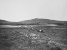
National Archives, Records of the U.S. Geological Survey, 1839–2001 [57-HS-277]
.
View of the Wind River Mountains, illustration by Charles Preuss, reprinted from A Report of an Exploration of the Country Lying between the Missouri River and the Rocky Mountains on the Line of the Kansas and Great Platte Rivers, printed by order of the United States Senate, 1843
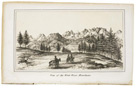
Charles Preuss was the German-born cartographer who served as the expedition’s mapmaker and artist.
Courtesy of the National Archives Library, Washington, DC
.
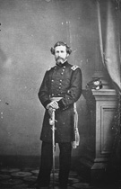
John C. Frémont, photograph from the Mathew Brady Collection, ca. 186065
National Archives, Records of the Office of the Chief Signal Officer [111-B-3756]
.