![]()
Monuments, Manifest Destiny, and Mexico
Summer 2005, Vol. 37, No. 2
By Michael Dear
© 2005 by Michael Dear
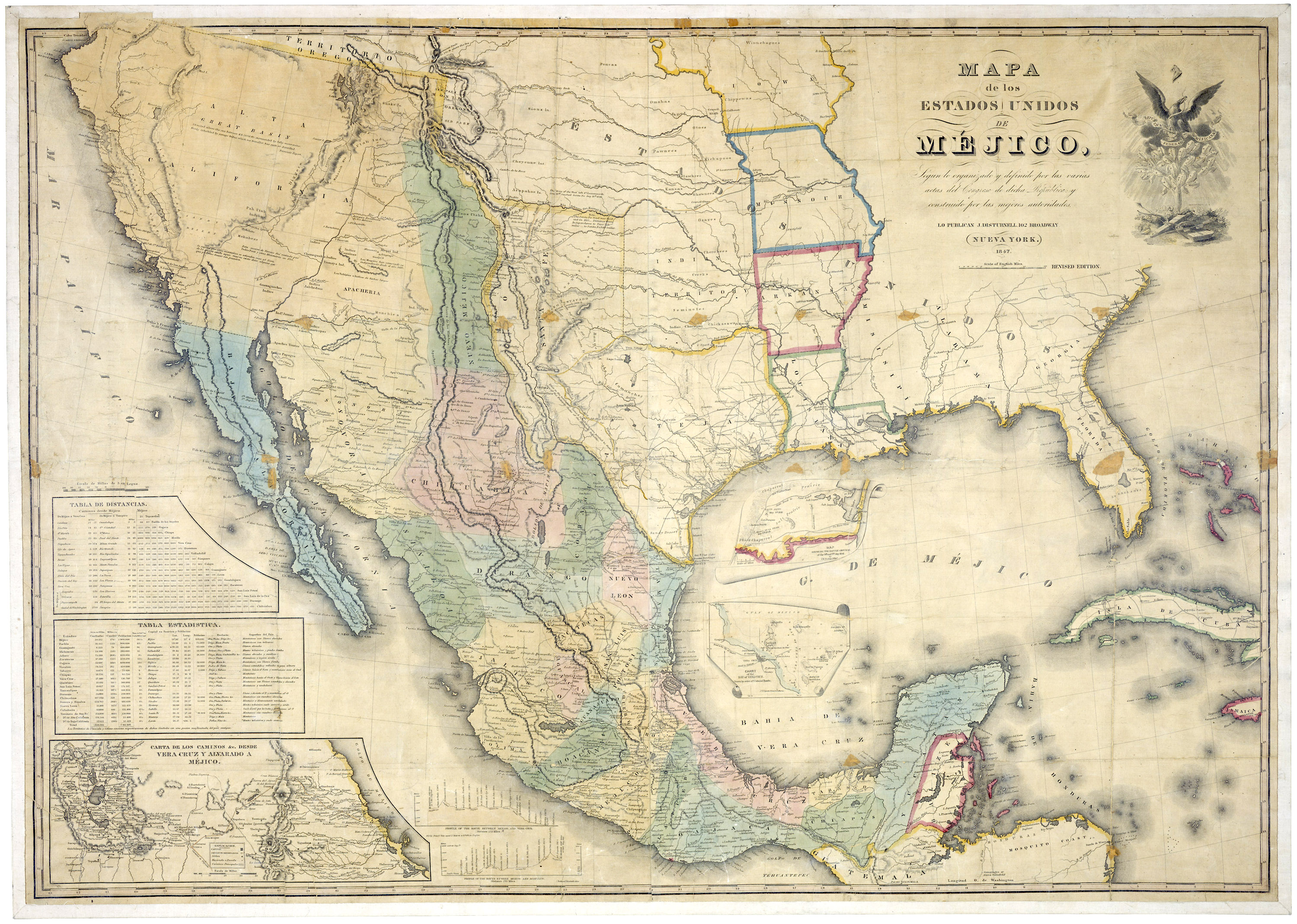
The Disturnell map of 1847 was appended to the Treaty of Guadalupe Hidalgo. (General Records of the U.S. Government, RG 11)
The survey of the U.S.-Mexico borderline, which followed the 1848 Treaty of Guadalupe Hidalgo, is sometimes disparagingly referred to as the stuff that "dime novels" are made of. To justify this characterization, some historians invoke tales of political intrigue, deaths from starvation and yellow fever, struggles for survival in the desert, and the constant threat of violent attacks by Indians and filibusters.
Yet, truth be told, the mid-19th century survey of the 2,000-mile border was a story of heroism, skill, and endurance of epic proportions. Though lacking the glamour of war or the grandeur of the Lewis and Clark expedition, the boundary survey is one of the greatest events in U.S. political history and remains deeply present in our contemporary lives.
Dime novel it's not; it is more a narrative of nation-building, centered in President James K. Polk's vision of manifest destiny.
The monuments erected by the boundary survey played a pivotal role in securing the line after the Mexican-American War. These obelisks and stone mounds literally marked on the ground the southernmost edges of the nation; they became fundamental points of reference in subsequent boundary disputes (of which there were many) and in the resurvey of the border that took place at the end of the 19th century.
The Treaty of Guadalupe Hidalgo and Its Aftermath
On February 2, 1848, a Treaty of Peace, Friendship, Limits, and Settlement was signed at Guadalupe Hidalgo, thus terminating the Mexican-American War. While the war was ostensibly about securing the boundary of the recently annexed state of Texas, it was clear from the outset that the U.S. goal was territorial expansion. Some decades earlier, the United States had secured the Louisiana Purchase, and President Polk now saw it as America's "manifest destiny" to acquire access to a western ocean through the acquisition of Nuevo México and the Californias (which included parts of the present-day states of New Mexico, Arizona, California, Nevada, Utah, and Colorado). Ultimately, Mexico was obliged to cede Alta California, Nuevo México, and northern portions of the states of Sonora, Coahuila and Tamaulipas.
The Treaty of Guadalupe Hidalgo, as it came to be called, was the outcome of a protracted series of negotiations between the two nations. On the U.S. side, Nicholas Trist proved to be an effective and sympathetic negotiator, who courageously ignored a recall notice from an irate President Polk (who believed Trist had conceded too much to the Mexicans) in order to complete discussions and sign the treaty. On the Mexican side, interim President Manuel de la Peña y Peña played a very important role by prevailing on Trist to stay on the job despite Polk's wrath and by bringing together warring factions at home to accept compromise.
Presented with a signed treaty, an outraged Polk feared the political consequences of repudiating it, and the treaty was eventually proclaimed on July 4, 1848. Mexico had gained peace and $15 million, but had lost one-half of its territory; and the United States had achieved the most important belligerent land grab in its history. The heroic Nicholas Trist returned to Washington, D.C., only to be cruelly ignored by President Polk.
In her definitive account of the making of the U.S.-Mexico boundary, Paula Rebert notes how the treaty accomplished two tasks essential to the integrity of la línea: the allocation of territory and the delimitation of the boundary. But these tasks were only the beginning. Also important were demarcation (locating and marking the boundary on the ground), map-making (to document the line), and maintenance and administration of the line thereafter.
The Treaty of Guadalupe Hidalgo required the designation of a "boundary line with due precision, upon authoritative maps, and to establish upon the ground landmarks which shall show the limits of both republics." The line would extend from the mouth of the deepest channel of the Rio Grande (also known as the Río Bravo del Norte); up the river to "the town called Paso" (present-day Ciudad Juárez); from thence overland to the Gila River, and down the channel of the Colorado River; after which it would follow the division between Upper (Alta) California and Lower (Baja) California to the Pacific Ocean.
The surveys themselves took six years to complete, beginning in 1849 and ending in 1855. Four separate boundary commissions were established by each country, the first three based principally in Paso and San Diego and charged with surveying different geographical sections of the 2,000-mile survey. The fourth commission was jointly convened in Washington, D.C., in 1856–1857 in order to complete mapmaking of the boundary line.

One of the 54 survey maps from the fourth boundary commission (a view of the initial point on the Rio Bravo del Norte), showing the U.S.-Mexico boundary in the El Paso del Norte District. (Records of the Boundary and Claims Commissions and Arbitrations, RG 76)
The various U.S. field surveys were plagued by acrimony and personal vendettas. In historian Carl Wheat's assessment: "if ever a mapping enterprise in the American West was cursed by politics, interdepartmental rivalries, and personal jealousies, it was the Mexican Boundary Survey." Certainly, the letters, diaries, and official memorandums by individuals involved on the U.S. side of the survey portray every other American participant as either a scoundrel or a self-promoter.
In contrast, the relationship between the U.S. and Mexican survey teams is reported as a paragon of rectitude and courtesy. At the close of the survey, the U.S. commissioner was able to write that "the utmost harmony has existed on this Commission between the Officers of both governments, and that all questions likely to produce the least difference have been settled harmoniously."
Such harmony was hard-won. The U.S. commissioner, William Hemsley Emory (known as "Bold Emory" by his contemporaries), and his Mexican counterpart, Commissioner José Salazar y Larregui ("a charming person, active, intelligent and polite, "according to Wheat) had together labored for many years, enduring perils, physical hardships, and the trials imposed by their political masters. They were also hindered by flaws in the treaty as well as by the borderlands' capricious geography. Most problematic was the treaty's specification that the land boundary from the Rio Grande was to strike west at a point eight miles north of Paso. However, the Disturnell map (appended to the treaty) showed Paso at a point 42 miles north of its true position. Disputes over the precise location for the land boundary after it parted from the river were not resolved until the Treaty of 1853, known as the Gadsden Purchase in the United States and as the Treaty of Mesilla in Mexico.
Surprises of geography caused other unexpected amendments to the line. The western end was designated as "one marine league due south of the southernmost point of the Port of San " from which it was to run eastward in a straight line to the confluence of the Gila and Colorado Rivers. The problem was that below the confluence, the Colorado took a sudden northward swing before bending south again to the Gulf of California. Had the straight line to the confluence been adhered to, a large crescent of land on the Colorado's south bank would have been allocated to the United States. Later adjustments placed the boundary where it first intersected with the Colorado, thus eliminating the Gila-Colorado confluence from further consideration.
On December 18, 1855, Commissioner Emory wrote to Washington, D.C.: "The field work of the boundary commission is . . . at an end." The successful completion of the 2000-mile survey was testimony to the enormous skill and endurance of the two longest-serving commission personnel: Emory and Salazar. The two men met again in Washington, D.C., under the auspices of the fourth boundary commission in order to complete the making of 54 survey maps. On September 21, 1857, they signed the final maps, and the boundary survey was officially adjourned. However, international disputes about the exact placement of the border continued for more than a century, and the line marked on the ground by the commissioners, in the form of boundary monuments, was to play a critically important role in resolving the burgeoning disputes between the United States and Mexico.
Marking the Line, 1849–1855
The boundary survey began on July 6, 1849, just south of the port of San Diego. For the next six years, U.S. and Mexican survey teams crisscrossed the borderlands, sometimes working collaboratively, other times independently, but always meeting regularly to confirm each others' work. Broadly speaking, the survey was undertaken in three sections, which were not in orderly sequence but instead varied in location according to the exigencies of physical hardship, uncertain supplies, and political winds in the respective national capitals.
- Between 1849 and 1851, the California survey was completed, from San Diego to the Colorado River.
- In 1851, Rio Grande survey teams began trekking downstream from Paso, only to be halted at Big Bend and beyond; the river survey began again in 1853, this time proceeding upstream from an initial point on the Gulf of Mexico, and was completed later that year by U.S. surveyors.
- Finally, a land survey between Paso and the Colorado River was relatively swiftly executed in 1855, once the initial point above Paso was settled by the Treaty of 1853.
As the surveys commenced, primary attention was understandably lavished on fixing the initial points (puntos iniciales) of the boundary line: at San Diego, the confluence of the Gila and Colorado Rivers, Paso, and the mouth (desembocadura) of the Rio Grande. In June 1849 the first U.S. boundary commissioner, John B. Weller, arrived in San Diego, accompanied by surveyor Andrew Belcher Gray and Maj. William Emory, then chief astronomer and head of the Topographical Scientific Corps. They were joined a month later by Mexican Commissioner General Pedro García Conde and surveyor José Salazar y Larregui. Emory and Salazar were enjoined to determine the first punto inicial "one marine league" south of the port of San Diego, another at the Gila-Colorado confluence, and to connect and mark these points with a straight line.
Disagreements arose immediately, since there was no standard measurement for a marine league. However, with a generous concordance that was to mark their entire collaboration, Salazar and Emory agreed to split the difference between their measurements. A location for the initial point was settled, and a temporary monument erected. The running of the line could begin.
Meantime, another U.S. survey team under Lt. Amiel Weeks Whipple headed out to establish an observatory at the Gila-Colorado confluence. Whipple built a stone monument on the first hill west of the confluence, and two more in the immediate vicinity. Emory and Salazar took charge of extending the line eastward from San Diego towards Whipple's mark. They constructed the first official boundary monument just east of the initial point in San Diego, where the line intersected the road to Baja California. As the line was run eastward, six other stations were noted on the maps of their survey.
In 1851, the two commissions met in Paso and drew up a formal plan of survey for the Rio Grande. However, this was followed only fitfully by scattered surveys until the arrival of Emory and Salazar (now Mexican commissioner following the death of Conde) in the summer of 1852. They divided the river into six sections: two each to be surveyed by respective national teams; and the first and last to be jointly executed. The eastern limit of the line, where the Rio Grande emptied into the Gulf, posed special difficulties because of the multiple shifting channels of the river.
Even after the deepest channel had been identified, problems remained because unstable dunes on either side of the desembocadura made it difficult to select sites for the two marble monuments planned for either side of the river. Eventually, two high dunes at the same astronomical meridian were selected. Reflecting some contention between the sides regarding the topographical measurements, the Mexican map of the desembocadura portrays both monument and river boundary, but the U.S. equivalent shows neither.
The 700-mile land boundary between the Rio Grande and the Pacific Ocean was the last to be completed, primarily because it had to await the Treaty of 1853. That settlement fixed the locations of the initial points at Paso and the Colorado River (the latter thereby superseding the original Gila-Colorado confluence punto inicial). The California line, from San Diego to the Colorado, had earlier been established. Seven marble or cast-iron monuments had been erected between the coast and the Colorado River: two monuments at each end of the line; another at the New River (near present-day Mexicali); and the remaining two at visible points along the intervening mountains. The commissioners were satisfied that seven monuments would be sufficient because so much of the land between the Pacific and the Colorado was "barren and can never be cultivated by either party."
E.L.F. Hardcastle and Francisco Jiménez were charged with erecting the cast-iron monuments, which had been manufactured in San Diego. The task was unexpectedly arduous, given the conditions in the desert, and involved adjustment to the location of earlier markers around the New River. Because long expanses on the California line were left unmarked, Hardcastle and Ricardo Ramírez (who had succeeded Jiménez) placed several supplementary monuments of loose stone west of the New River.
By July 1851, a marble monument at the Pacific Ocean was approved, and the California survey was officially terminated. The following year (April 1852), John Russell Bartlett, who had spent most of his time as U.S. boundary commissioner on an extended (and expensive) tour of the American West, happened upon the Pacific monument. In his published reminiscences, he later described it as: "an obelisk about twenty feet in height . . . and is seen from a great distance on land as well as by vessels at sea."
Connecting the initial points from Paso to the Colorado River was now all that remained to be done. Since the land lines were mathematically defined in the Treaty of 1853, their demarcation was a relatively simple task. The 1853 treaty had reconstituted the U.S. Commission as a well-funded unit under Emory's leadership, but the Comisión de Límites Mexicana, led by the able Salazar, was chronically underfunded. (In a gesture of goodwill, Emory had discreetly secured funding from the U.S. in support of Salazar's work.) Matters were not helped when Salazar was imprisoned for a brief period at the behest of Mexican President Santa Anna. In any event, Emory initially proceeded alone with the survey westward from the Rio Grande, while Salazar and his small retinue remained in Paso to complete the placement of three permanent monuments.
Old monument number 16, looking east, is an example of a simple stone marker that Major Emory's team used to mark the location of the boundary. (76-OM-1-144)
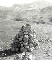
Heading west, Emory's team often erected stone mounds as monuments, supplementing these with careful topographical sketches of the surrounding countryside, in order to "perpetuate the evidences of the location of the boundary, in the event of Indians removing monuments erected on the ground." Ten substantial monuments of dressed stone laid without mortar were located along the 31°20' parallel and the meridian connecting it to the 31°47' parallel. This latter parallel was marked with simple stone mounds except in the vicinity of the Rio Grande/Río Bravo at Paso, where Salazar had erected three permanent monuments close to a U.S. monument of dressed stone.
Despite Emory's objections, Salazar insisted on conducting his own survey of the boundary west from Paso. This turned out to be a prudent decision, because the Mexicans were unable to locate many monuments that the U.S. claimed to have established. Salazar erected monuments to replace those that were missing and also reconstructed several unsubstantial U.S. monuments. Perhaps unsurprisingly, the two commissioners could not agree on the inventory of structures along this section of the line: Salazar claimed 10 monuments, but his map showed 9; the final U.S. map depicted 8. Forty years later, the boundary resurvey was to experience much "confusion and uncertainty" because of these inconsistencies.
The last hurdle facing the survey teams was the desert of Arizona and Sonora, which lay between them and the Colorado River. Because the terrain and climate were extremely inhospitable, and potable water was scarce, the U.S. and Mexican commissioners agreed to cooperate in a joint survey. The iron monument previously installed at the confluence of the Gila and Colorado was removed to its new site on the Colorado and designated as "Monument I." The line was then extended eastward from the river, maintaining the practice of using Roman numerals to identify monuments. However, the eastward march was halted by the absence of water, and it was left to Nathaniel Michler and Francisco Jiménez, working westward along parallel and meridian out of Paso, to eventually complete the Arizona/Sonora line to the Colorado River.
The 54 boundary survey maps, signed by Commissioners Emory and Salazar during the 1856–1857 Joint Boundary Commission meetings in Washington, D.C., represent a triumph of skill, persistence, endurance, and not a little heroism. Emory understood that the maps would attest to the completion of the survey, verify the geographical location of the line, and have standing in international disputes. He and Salazar wrote:
[T]hese maps and views . . . shall be evidence of the location of the true line, and shall be the record to which all disputes . . . shall be referred. . . . [T]he line shown by these maps and views shall be regarded as the true line, from which there shall be no appeal or departure.
Under the terms of the Treaty of Guadalupe Hidalgo, the commissioners' words gave the maps and views an authority equal to the treaty itself.
In practice, needless to say, matters were a little more complicated. Carl Wheat's account notes: "In effect, the maps were the boundary, and remained so for another generation." But Paula Rebert's judgment seems closer to the truth: "The true boundary was the boundary marked on the ground." In subsequent disputes, what was actually on the ground (including the monuments) had stronger legal claim than the maps. Thus it was that, as the 19th century drew to a close, the need for greater precision about what was on the ground became imperative.
The Boundary Resurvey, 1891–1894
As the borderlands' population grew during the second half of the 19th century, disputes over the exact location of the boundary line became more frequent.
On July 29, 1882, delegates from both countries recommended a military reconnaissance of the entire land boundary from Ciudad Juárez-El Paso to the Pacific. Its purposes were to report on the border communities, identify and record the condition of monuments, and determine how many more were needed. In charge of the U.S. reconnaissance was Lt. Thomas W. Symons; his Mexican counterpart was Gen. Ignacio Revueltas. They agreed to travel together from El Paso to San Diego, but Symons departed alone in July 1883 and completed the preliminary survey without Mexican assistance.
En route to the Pacific, Symons found much evidence of social disarray along the growing borderlands. Many boundary monuments were either missing or in a state of disrepair. By September 1883, Symons stood alongside marble monument number 1 at the Pacific. It was chipped and defaced, and he recommended that a fence be erected to protect it. Symons's team had traveled 1,252 miles and charted 52 monument sites in order to complete the reconnaissance. Now the work of remarking the line could begin in earnest. But because of political turmoil in both countries, nothing happened for almost six years until, in 1891, a boundary commission was recreated to assume the task.
The resurvey plan was based on identifying the original monuments that, after verification, were to be regarded as definitive evidence of the boundary. No deviations from the original line were permitted. The maps from the original survey played an important part in the identification process. John Whitney Barlow and Jacobo Blanco, respectively U.S. and Mexican commissioners, met at El Paso in February 1892. Their instructions were to resurvey the line, locate and rebuild the old monuments, and install additional markers as necessary. Both teams were expected to work alongside each other, but the better-equipped Barlow survey soon outpaced the Mexican team, and the respective commissioners ran the line separately, comparing results as they proceeded.
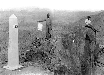
The resurvey team of 1891–1894 established monument number 185 at La Sierra del Tule. (77-MB-3-32)
Barlow and Blanco increased the number of boundary monuments from 52 to 258. The new monuments were acquired in El Paso at a cost of $150 apiece. They were iron columns 6 feet high, 12 inches square at the base, pyramidal in shape at the top, and set in concrete. Plaques in English and Spanish read: "Boundary of the United States [or Mexico], treaty of 1853, reestablished by the treaties of 1882–1889."
The resurvey teams encountered inevitable difficulties and confusions during their journey. Frequently, the original monuments were difficult to find, especially in mountainous terrain. Errors in the original survey meant that some earlier monuments were incorrectly positioned; such mistakes were either quietly adjusted or left unchallenged so as to avoid the need for negotiating new treaties of reconciliation. At the Tijuana River, prior floods had buried the monument under several feet of sand, so Barlow and Blanco reestablished the obelisk 1,200 feet east of the original, on higher ground.
More problematically, some of the old monuments had been swamped by the encroachment of borderland settlements. A prime example of this was in Nogales, Arizona, where an enterprising saloon proprietor had built his establishment around boundary marker number 26, which was now little more than a jumble of stones propped against the saloon wall. Fearful for the integrity of the line, Commissioner Barlow recommended that a 60-feet reservation line be established along the entire land boundary to prevent further encroachment. While awaiting the federal response to his proposal, Barlow tore down part of the saloon wall and re-erected the monument, now numbered 122. Later, after President William McKinley authorized a 2-mile long, 60-foot wide reserve along the Nogales boundary, all offending structures on the U.S. side were removed.
It is worth noting that many of the difficulties encountered by the resurvey commissions were the result of deliberate human interference. Salazar and Emory had long ago documented the destruction of the monuments and stone mounds by marauding Indians. Continuing destruction also resulted when monuments were dismantled for use as building materials, or as an expression of antipathy toward the United States. But also to blame were the actions of ranchers and miners north of the border, who destroyed or moved markers in order to gain control over land and mineral resources.
By June 1894, the work of the resurvey commissions had come to an end. Boundary monument number 1, on the Pacific Ocean, was redesignated as number 258, since the surveyors had worked west from El Paso. The old monument was sent to San Diego for polishing and reengraving and was later reinstalled within an iron fence to prevent further vandalism. The resurvey effort terminated in an acrimonious haze, since the teams had discovered errors in the original survey that resulted in a miscalculation of territorial allocation on both sides of the border. In aggregate, these errors, if corrected, would have resulted in a net gain of territory to Mexico of more than 300 square miles. Ultimately, because of fears that further adjustments would cause unending litigation, both sides withdrew from further contention. Once again, the evidence of what was actually on the ground trumped any concerns based in mathematical or cartographic exactitude.
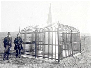
An 1894 photograph shows the southeast view of monument number 258 (old monument 1) after renovation and the erection of a protective fence. (76-MB-3-147)
The final report of the resurvey commission was published in 1898. In the following two decades, a further 18 monuments were erected, bringing the total to 276. To avoid any confusion with respect to numbering, both nations retained the original sequence, 1 to 258, and noted more recent additions by lettering (1-A, 1-B, and so on). The 18 additions were principally to "more perfectly mark" the line. For instance, a 1906 report from the International Boundary Commission noted that the only visible indication of the border between the twin towns of Naco (in Arizona and Sonora respectively) was "a railroad spike driven into its head in the ground." The commission recommended that three additional monuments (92-A, 92-B, and 92-C) be erected and that a 60-foot setback of all building from the boundary line be instituted, since "much of the trouble between the citizens of the two countries last Spring would have been avoided had there been no buildings, canals or freight cars near the boundary to serve as places of concealment during the rioting and shooting."
Elsewhere, in 1909 the International Boundary Commission undertook the restoration of monument 221 and the erection of a new monument 220-A to clarify the separation between the towns of Calexico (California) and Mexicali (Baja California). The restoration task had been occasioned by the famous flood of 1905 when the Colorado River burst its banks at Yuma, creating the present-day Salton Sea, but also "destroying in its path a good share of the town of Mexicali." The flooding actually stopped short of the monument, which remained in place after the surrounding landscape was regraded. Finally, a number of monuments were erected on new bridges built across the Rio Grande, including Brownsville-Matamoros (1910) and Laredo-Nuevo Laredo (1912). The monuments were usually located on the bridge at the center of the "normal channel" of the river.
From Monuments to Markers, Fences, and Fortifications
In the vast empty expanses or in the bustle of rapidly growing cities that characterize the 2,000-mile border separating the United States. and Mexico, it is easy to overlook the 276 boundary monuments. They are, after all, relatively modest structures, perhaps regarded by most people as quaint relics of a frontier heritage. And yet, the monuments continue to be the focus of local, national, and international tensions.
With the completion of 276 monuments, the official monumentation program was terminated. Henceforward, both countries agreed that any further delimitation would consist of smaller "markers" of concrete. By 1975, already 442 markers had been added, principally in and around the sprawling border cities and towns; another 51 were added in 1984. As population numbers and densities increased, efforts to "connect the dots," that is, to build fences along the line between monument and marker became commonplace. By the end of the 20th century such fences were being replaced by massive fortifications, most spectacularly realized in Tijuana-San Diego and Ciudad Juárez-El Paso, in an attempt to staunch the flow of cross-border traffic in humans and illegal contraband. Such interdictory structures have recently been extended into suburban and rural districts throughout California and Arizona. A century or more after Salazar and Emory, and Barlow and Blanco, we have begun to connect their monuments and markers, building a wall between the United States and our Mexican neighbors.
Michael Dear is professor and chair of the Department of Geography at the University of Southern California. His research focuses on present-day cultural ecologies of the U.S.-Mexico borderlands. His most recent book is Postborder City: Cultural Spaces of Bajalta California (New York: Routledge, 2003; co-edited with Gustavo Leclerc), and he is currently writing a book with Héctor Lucero entitled El surgimiento de Bajalta California.
Note on Sources
National Archives holdings on the U.S.-Mexico borderlands include field notebooks, topographical sketches, maps, trigonometric and astronomical readings, photographs, memorandums and letters, as well as official reports. For this article, I have used a combination of textual, cartographic, and photographic sources. Most sources are to be found in Records of Boundary and Claims Commissions and Arbitrations, Record Group 76.
The most useful textual resources have been:
William H. Emory, Report on the United States and Mexican Boundary Survey made under the direction of the Secretary of the Interior, 3 vols. 34th Congress, 1st session, 1857; and
Memoria de la Sección Mexicana de la Comisión Internacional de Límites entre México y los Estadas Unidos que restableció los monumentos de El Paso al Pacífico (New York: John Polhemus y compañia, 1901.)
The two most significant cartographic records are:
U.S.-Mexico Boundary Survey, 1849–1855, final maps (54, in 13 folders, plus 4 index maps and 5 maps of islands in the Rio Grande); and
Report of the International Boundary Commission, United States, and Mexico, 1891–1896, maps (24 maps and relief cross-sections from resurvey of boundary from San Diego to El Paso, plus 2 index sheets).
The prime source for photographic records of the 1891–1896 border resurvey is "Albums of Photographs of Boundary Monuments on the Mexican-American Border 1892–1894."
Some of these photographs also appear in published reports, most notably the Memoria, and the proceedings of the U.S. Department of State, International Boundary Commission, United States and Mexico. I made specific use of three of IBC's reports:
"Monumentation of the Railroad Bridges between Brownsville and Matamoros, and Laredo and Nuevo Laredo" (1910, 1912);
"Placing of an additional monument to more perfectly mark the international boundary line through the towns of Calexico, California, and Mexicali, Baja California" (1909); and
"Placing of additional monuments to more perfectly mark the international boundary line through the town of Naco, Arizona-Sonora" (1900).
The principal Spanish-language source for photographs of the 1891–1894 resurvey is Vistas de los monumentos, a lo largo de la línea divisoria entre México y los Estados Unidos de El Paso al Pacífico (New York: John Polhemus y compañia, 1901), under the direction of Mexican Commissioner Jacobo Blanco. The documents governing the Mexican resurvey are collected in Luis G. Zorilla, Monumentación de la frontera norte en el siglo XIX (México D.F.: Secretaría de Relaciones Exteriores, 1981).
John Russell Bartlett was the second U.S. boundary commissioner, who reputedly spent over half a million dollars of boundary survey money on personal travel throughout the American and Mexican West. Although he contributed practically nothing to the survey, he later produced a classic tale of travel in the region entitled Personal Narrative of Explorations and Incidents in Texas, New Mexico, California, Sonora, and Chihuahua (2 volumes, 1854; available as a 1965 reprint from The Rio Grande Press, Chicago, IL).
In terms of secondary source materials, the standard account of cartographic history in the American west is by Carl Irving Wheat, Mapping the Transmississippi West, 1540–1861, vol. 3, From the Mexican War to the Boundary Surveys, 1846–1854 (San Francisco: Institute of Historical Cartography, 1959).
The definitive historical narrative of the 1849–1855 U.S.-Mexico boundary survey is by Paula Rebert, La Gran Línea: Mapping the United States-Mexico Boundary, 1849–1857 (Austin: University of Texas Press, 2001).
A lively, well-researched history of the border region to the present day (including both boundary surveys) is Leon C. Metz's Border: the U.S.-Mexico Line (El Paso, TX: Mangan Books, 1989).
Several chapters in a biography of W. H. Emory report on his boundary survey experiences, making copious use of his letters, diaries and reports. See L. David Norris, James C. Milligan, and Odie B. Frank, William H. Emory: Soldier-Scientist (Tucson: University of Arizona Press1998). The life of Mexican Commissioner Salazar is less well documented, but see Luz Maria O. Tamayo Perez and José Omar Moncada Maya, "José Salazar Ilarregui, 1832–1892," in Patrick H. Armstrong and Geoffrey Martin, eds., Geographers: Bibliographic Studies, vol. 23 (New York: Continuum, 2004): 116–125.
Thanks to:
NARA staff, especially Raymond Cotton of the Cartographic Section, and Mary C. Ryan, managing editor of Prologue; Marje Schuetze-Coburn, director of USC's Specialized Libraries and Archival Collections, and Barbara Robinson of USC's Boeckmann Center for Iberian and Latin American Studies, for assistance in locating archival sources; Héctor Lucero, of the Universidad Autónoma de Baja California, Mexicali, for companionship and insight during our explorations of the U.S.-Mexico borderlands; Paula Rebert, for generous advice and guidance concerning the 1849–1855 boundary survey; Greg Hise, Paula Rebert, and Jennifer Wolch, for comments on a draft of this essay; and the National Geographic Society's Committee for Research and Exploration, and the College of Letters, Arts, and Sciences at the University of Southern California, for financial support.I hereby absolve all these individuals and institutions for any sins of omission or commission in this essay; any errors that remain are my responsibility.