![]()
The 200th Anniversary of the Survey of the Coast
Spring 2007, Vol. 39, No. 1
By John Cloud

Ferdinand Hassler founded the Survey of the Coast in 1807 and introduced precise geodetic surveying methods never before used in North America. Nearly two centuries later, the triangle network covers the continent of North America. (Records of the Coast and Geodetic Survey, RG 23)
The Survey is based on a network of triangles, of which the first was located on the shores of Long Island, with one side of the triangle consisting of a carefully measured baseline. (Records of the Coast and Geodetic Survey, RG 23)
Climbing the hills of the sheep-grazed headlands of Long Island, New York, Ferdinand Hassler and his men were not interested in gazing at the ships coming to and from the rapidly growing port of New York in the early years of the 19th century.
They had something much more serious in mind.
At night, they measured the positions of the stars; by day, they measured the directions and angles to signals on other hills. This mathematical analysis of time and the stars yielded Hassler the position of the hilltop and allowed him and others to trace a web of triangles across the landscape, anchored here and there by a carefully measured baseline.
Hassler's objective was to chart the country's coast for the benefit of the mariners sailing to and from New York. But before the mariners could find their positions on his maps, Hassler had to position the continent. In keeping with many nations in that era, he created a spatial reference system based on a prime meridian, the line of zero longitude, tailored to the new nation. European nations zeroed their longitude systems on their capital cities, but Hassler took an American tack. The great ports of the nation in that era stretched from Boston in the north to Charleston in the south. Washington itself was still a raw new settlement on the Potomac. Hassler devised a system in which the line of zero longitude of the nation ran through the great middle port of New York.
Thus began, two centuries ago this spring, the nation's first Survey of the Coast, headed by Hassler, a young Swiss immigrant personally chosen for the job by President Thomas Jefferson. It also marked the beginning of the oldest scientific agency in the U.S. Government, what is now called the National Oceanic and Atmospheric Administration, or NOAA—the agency that charts the seacoasts for ships, predicts the path of hurricanes, and protects delicate coral reefs and spawning salmon.
Hassler's work was the result of legislation in 1807 that authorized the President "to cause a Survey to be taken of the coasts of the United States" for various purposes. Jefferson had just received reports from the expedition he dispatched to explore the recently purchased Louisiana Territory, the Lewis and Clark Expedition. Now, Congress had given him discretion "to cause proper and intelligent persons to be employed" in carrying out a rigorous survey of the nation's coastline—which would eventually grow to fulfill Jefferson's dream of a nation facing both the Pacific and the Atlantic.
Hassler had received a scientific education and had served as both official surveyor of his Swiss canton of Berne and also its attorney general. Like so many others, though, he felt the Old World to be confining, so he sailed to America armed with hope, a large technical library sealed in barrels, and his very own meter, a heavy iron bar marked with the exact length of the French unit of measure.
The Survey of the Coast soon became known as the Coast Survey, and later in the 19th century it was renamed the Coast and Geodetic Survey. In some respects, it would have been more accurate for Hassler to have named his enterprise the Geodetic Survey at the onset.
Geodesy is the ancient science of the size and shape of the Earth and the determination of the exact locations of very specific points on the Earth's surface. Hassler's emerging geodetic network was the fruit of both brute-force bushwhacking up hill slopes and also advanced trigonometry, in about equal measures. Only with that well-defined geodetic skeleton, as it were, could Hassler and his staff then turn back to the coast of the Atlantic to chart the harbor entrances and reefs and treacherous shoals of such a supremely maritime nation as was the United States in that era. Hassler and his staff worked outward in both directions from Long Island along the Atlantic coast, and then wherever American territorial shores were won or declared. Hassler had rivals and critics who demanded to know when the "Survey of the Coast" would be completed. He eventually prevailed with the response that "Never" was an appropriate answer. Every permanent scientific agency in the government is descended from Hassler's persistence.
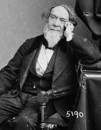
Alexander Dallas Bache (1806—1867) was a giant of American science in the 19th century. A great-grandson of Benjamin Franklin, he was a gifted educator and builder of an observatory of terrestrial magnetism in Philadelphia before assuming the post of superintendent of the Coast Survey in 1843. (Library of Congress)
Hassler directed the Survey until his death in 1843 and was succeeded by Alexander Dallas Bache, who was superintendent until he died in 1867, essentially a late casualty of the Civil War.
Although they were near-contemporaries, Hassler seems to have dwelt on a far distant coast compared to Bache. Direct perceptions of Hassler are scarce. Hassler left few surviving papers, apart from small batches of letters now in the collections of the New York Public Library and the American Philosophical Society in Philadelphia. Bache, on the other hand, became a giant of American science, and his correspondence with his contemporaries has occupied generations of scholars.
Bache was a great-grandson of Benjamin Franklin and was educated to the highest standards available in the United States in his era, graduating at the top of his class at West Point. In 1836, while waiting to assume the position of president of the newly established Girard College, in Philadelphia, he embarked for Europe for a tour of scientific academies on the continent. He paid particular attention to the German polytechnic schools, which offered courses of a scientific rigor far beyond those available in the United States. Back at home, Bache published an eight-volume report on what he had seen in Europe and then settled in at Girard College, where he established his own magnetic observatory. But then Ferdinand Hassler declined and died, Bache replaced him, and the history of American science changed.
Bache was impeccably well connected, and he used every connection to advance the Survey, quadrupling its budget within a year. Bache had identified the level of science he wanted to pursue in Europe; as head of the Survey he would bring European science to the United States and reforge it as American science. Early in his tenure he welcomed German scientifically trained immigrants to the Survey, particularly two: Julius Hilgard and Charles Anthony Schott. Hilgard was an organizer of men and ideas who later on became superintendent of the Survey himself. Schott became a computer in the Survey, and two years later he became the chief computer, a role he performed for the next 50 years. Schott was the most significant unknown American scientist of the 19th century.
Under Bache the Survey expanded in every sense. Extending his magnetic observatory research nationwide, he brought systematic terrestrial magnetic work into the Survey. He either purchased the finest European scientific equipment available, like the meridian transit telescope bought in 1845, or he had the instruments designed and built in the shops of the Survey.
Hassler had concentrated on the geodetic network, and the endless difficulties of training personnel and raising funds, and he gave less attention to actually publishing charts based on his decades of work. Bache grasped that the Survey work was of little use unless it became visible and useful to mariners. As soon as he took command, the copper plates that had been under way for years were finished, and a series of magnificent charts appeared, the finest cartography yet produced in the New World. It has been said that Bache built on Hassler's foundations, which meant, in fact, he printed Hassler's plates.
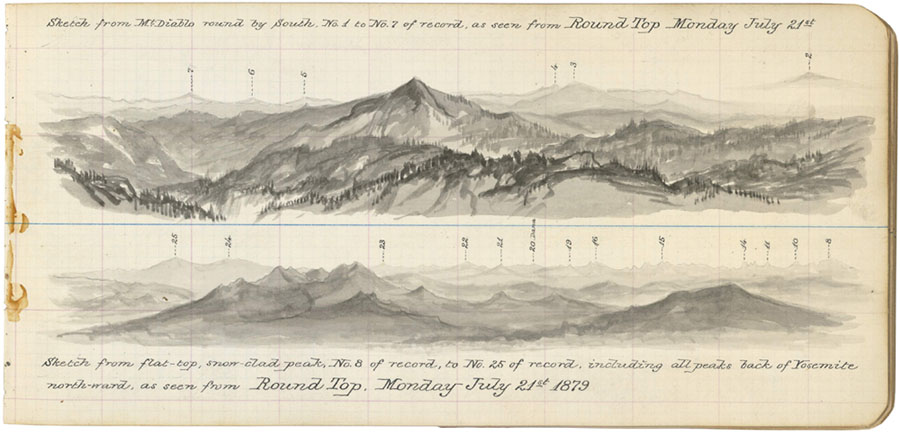
Louis A. Sengteller s two field sketches capture a 360° view of prominent peaks visible from Round Top (10,381 feet) in Eldorado National Forest, California, in July 1879. (Records of the Coast and Geodetic Survey, RG 23)
The Coast Survey expanded under Bache in part because the United States acquired many new coasts. The entry of Florida and Texas secured the entire Gulf Coast, and the Mexican War delivered California, and hence the Pacific Coast. In 1850 Bache dispatched Coast Survey personnel to California to begin the West Coast Survey. In terms of both geodesy and American settlement, the west coast was Aqua Incognita. The nearshore waters were far deeper than on the gentle slopes of the Atlantic coast, and the shapes of the continental slopes there were evocative and strange. George Davidson, who became the leader of the West Coast Survey for almost half a century, became a premier scientist of California by attempting to decipher the patterns of the coast.Meanwhile, back east the Civil War loomed. Bache was a fervent defender of the Union cause, in contrast to his sometimes rival Matthew Fontaine Maury, the oceanographer of the U.S. Navy Hydrographic Office who joined the Confederate Navy. Bache directed the entire Coast Survey to shift activities to support the war effort. Bache was a member of the "Commission on Conference," a secret committee set up to devise strategy for the anticipated naval blockade of the Confederates along the Atlantic and Gulf coasts. He directed a compilation of the most recent revisions of nautical charts, sailing directions for mariners, and even updated data on how compass needles departed from pointing true north for the Atlantic coast from Delaware Bay south and around Florida along the Gulf coast to Texas. These "Notes on the Coast of the United States," which were published in confidential memoirs in 1861, were invaluable to the war effort and survive as unique "snapshots" of the ecological state of the coastal areas as they were on the eve of great changes.
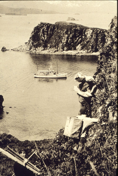
Crew members from the Survey ship Wildcat carry heavy cases protecting telescopes and other surveying equipment up a cliff on Cathedral Island, a small island near Kodiak Island, in 1928. (NOAA Historic Coast and Geodetic Survey Collection)
Bache suffered some sort of aneurism while preparing fortifications for Philadelphia as General Lee's army approached; he remained a stricken shadow, dying in 1867. He left behind not only the greatly expanded Coast Survey but also a brace of American scientific institutions that continue to guide the nation—the National Academy of Sciences, the American Association for the Advancement of Science, and even the Smithsonian Institution, for which he was instrumental in securing Joseph Henry to be its first secretary.
In the same year the Survey lost Bache, it acquired Alaska, by virtue of the American purchase of the territory from Russia. The Survey was dispatched to begin to chart the coastlines of the vast territory and to undertake basic investigations of Alaskan seas and the creatures that lived in or on them. These were the beginnings of a system for environmental monitoring of American ecological resources that eventually culminated in NOAA in the 20th century. In 1871, the government created the Commission on Fish and Fisheries, its first environmental agency. One of the first things the commission did was collaborate with the Coast Survey on a pioneering project to map and monitor oyster beds in Chesapeake Bay and later the estuaries of the rivers of Virginia and Maryland. The Coast Survey also redoubled its mapping of the changing coastlines of the United States as well as the production of vividly detailed perspective views of coastal headlands and approaches to harbors, which were published in numerous revised editions of the Coast Pilot series for mariners.
The Coast Survey had historically hugged the coast, wherever that coast went. In the 1870s, as the Survey developed into a major player in international science, it marched overland across North America to tie the Atlantic and Pacific coasts together. The project was the great arc of the 39th parallel survey, in which a band of geodetic triangles was advanced across the continent along the line of 39 degrees north latitude. This tied the separate coastal networks into what would, over decades, become the major spatial reference frame system for the United States. Along the way, the organization changed its name to the U.S. Coast and Geodetic Survey, in part to reflect the enlarged scope of the Survey, and in part to placate congressmen who were wondering why an outfit called the "Coast Survey" was spending so much money way up in the mountains of Colorado!
The science that the Survey practiced was increasingly global in scope. The Survey was a participant in many late 19th-century international scientific unions and initiatives, including the 1884 conference that declared the Greenwich Meridian as the world's Prime Meridian and the French metric system as the global scientific standard. Following that, Otto Tittmann, later a superintendent of the Survey, traveled to Paris to secure new standards of the metric system, which he brought back to Washington on a steamship. With the new platinum meter bar in hand, the Survey finally retired Hassler's iron bar. Eventually the division of the Survey responsible for these standards, the Office of Weights and Measures, was spun off as the independent National Bureau of Standards, which later became the National Institute of Standards and Technology, or NIST.
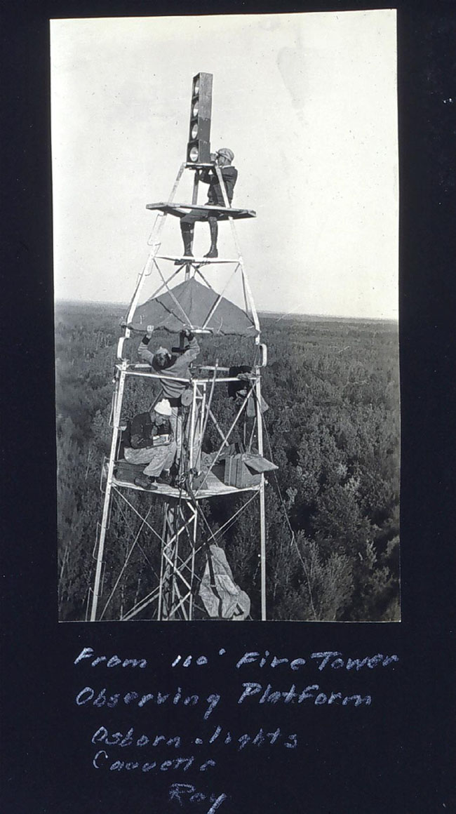
Triangulation surveys in relatively flat terrain, especially in forested areas, required the use of tall towers. Arrays of battery-powered lights made the towers visible over longer distances. These lights were installed on a 110-foot tower at geodetic station Northome, in Minnesota, in 1934 by a survey party working under the legendary Survey geodesist Carl Aslakson (1896—1982) (NOAA Historic Coast and Geodetic Survey Collection).
After the Spanish-American War and the annexation of Hawaii brought the coasts of Puerto Rico, Hawaii, and the Philippines into the domain of the Survey, its ships were soon plying the waters from the Arctic Ocean to the Caribbean Sea, and the North Pacific Ocean from one side to the other. The Survey also changed homes in the American government. Since the era of Hassler, the Coast Survey had been an agency of the Treasury Department. When the Department of Commerce and Labor was formed in 1903, the Coast and Geodetic Survey moved into it. In 1913, Labor was segmented out as a separate department. The Survey remained in Commerce and has been there ever since.
The early 20th century ushered in another golden era for the Survey. Benjamin Peirce, who succeeded Bache as Superintendent of the Survey, had noted as early as 1855 that there was a limit to the accuracies of any particular suite of instruments and technologies, and that at a certain point more observations will not improve the results. Hence, he noted: "A wise observer, when he perceives that he is approaching this limit, will apply his powers to improving the methods, rather than to increasing the number of observations. This principle will thus serve to stimulate and not to paralyze effort; and its vivifying influence will prevent science from stagnating into mere mechanical drudgery." The Survey was characterized by a relentless enterprise to invent new instruments and develop or adapt new techniques to old tasks. This process was personified in Ernst Fischer, who became chief of the Instrument Division almost as soon as he joined the Survey. He designed dozens of instruments, of which his masterpiece was the great Tide Prediction Machine, finished in 1912. The machine was one of the most sophisticated analog computers ever built, using sliding pulleys and braided metal cord to construct mechanical solutions to determine the tides for any coastal station at any time. It was used for most of the 20th century.
Another war, World War I, mobilized the Survey on a scale comparable to what Bache had done but in a very different way. E. Lester Jones, who became head of the Coast and Geodetic Survey in 1915, orchestrated the congressional law that allowed Survey personnel to go into military service at ranks requisite with their skills and abilities. After the war ended, they returned to civilian status, but Jones insisted they retain pay rates comparable to what they had received while in the military.
World War I, on land, has been called the "chemists' war" because of the profound impacts of chemical munitions on its progress and results. The war on the oceans was the acoustic war, reflecting the changed realities of submarines and defenses against them, and the rapidly changing knowledge of the oceans opened up by acoustic instruments. Survey scientists applied acoustic instruments designed for submarine detection to entirely new applications to position survey ships at sea, essentially extending the land-based geodetic network out to sea. The system they developed, called Radio Acoustic Ranging (RAR), utilized little bombs of TNT exploded in the water as an acoustic source for triangulation. Unorthodox as it was, RAR was the very first precise positioning system in human history to be entirely unhinged from visual observation. A century after his work, the Survey had finally left Ferdinand Hassler and his telescopes on Long Island behind.
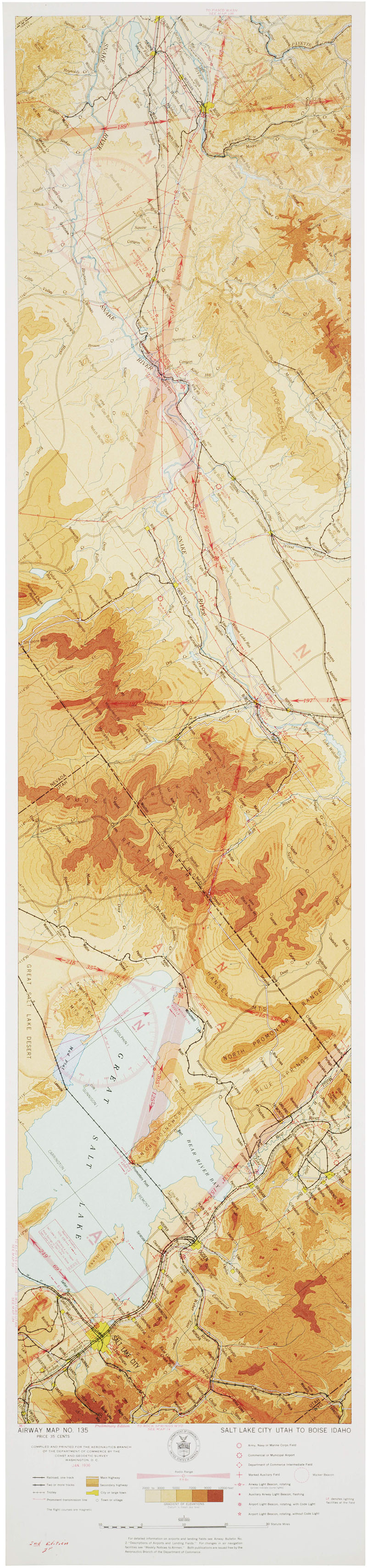
The original aero-nautical charts, produced from 1927 to 1937, were strip maps, oriented along the line of flight between two airports, and color-coded by elevation of the terrain. A section of a Salt Lake City map is shown here. (Records of the Coast and Geodetic Survey, RG 23)
The postwar world was full of airplanes, flown by pilots who needed maps. Jones, while on leave from the Survey as Colonel Jones on the western front in World War I, had advocated the use of aerial photography for mapmaking and had also advocated the production of maps for aviators. Immediately postwar, aviation maps were produced exclusively by the Army and Navy, until the Civil Aviation Act of 1926 began the modern era of civilian flying. Under the act, the Coast and Geodetic Survey was given responsibility for civilian aviation maps. For a century, the Survey had created nautical charts, so it now produced "aeronautical" charts. The Survey's charts were widely sought after as being superior to all others, and the Survey's name for them was adopted around the world.
The Survey acquired new responsibilities as technologies changed, but it retained old responsibilities as well. Since the Mississippi River Commission was founded in 1879, a high-ranking officer of the Survey had always been a member. In 1927 a disastrous flood on the Mississippi River wreaked damage and suffering on a scale that was unparalleled in modern American life. Herbert Hoover chaired a commission to investigate the flood and its causes, a role whose success sent him to the White House. The commission asked the Coast and Geodetic Survey to analyze the floods and map them. The resulting map, which shows how levees were deliberately dynamited to flood the bayous and spare the city of New Orleans, contains a graphic drama unmatched until the era of NOAA's maps of the damage caused by Hurricane Katrina.
E. Lester Jones died in 1929, the victim of poison gas exposure in World War I. His Survey and the rest of the federal government were soon engulfed in the Great Depression. The Survey's scientific ranks thinned as budgets shrank, but later the Survey swelled to contain thousands of personnel, most of them unemployed people hired through the Public Works Administration. They marched along tens of thousands of miles of roads and railroad tracks, tracking the changes in elevation. And they marked punch cards and tallied hundreds of thousands of changes in American place names through the work of the Board of Geographic Names.
When President Roosevelt and the other leaders of the New Deal shifted priorities to the defeat of the Axis Powers, the Coast and Geodetic Survey threw itself entirely into the fray. Many Survey officers transferred into military service, as their predecessors had done in World War I, but the rest of the personnel of the Survey, although they were civilians, were entirely mobilized for the war effort. Survey staff members were experts in geodesy and seismology and magnetism, but above all they were superb cartographers. Geodesy aided their cartographic contribution. Most maps are designed in series and prepared on very specific map projections. The Survey had designed and built the finest instrument of its kind in the western hemisphere, the great projection ruling machine. It was in constant use, three eight-hour shifts a day, preparing the projection frameworks for maps and charts issued by all American mapping agencies during the war. By the end of the war, the Coast and Geodetic Survey, a small agency, had published over 100 million maps and charts for the war effort.
A single sentence in the preliminary version of the Survey's official history of its activities in World War II notes that various members of the Division of Terrestrial Magnetism and Seismology used their instruments to monitor ground vibrations at "an atomic test in New Mexico." The test was the world's first atomic bomb, detonated at Trinity site. In a sense, that was the Survey's introduction to the Cold War, and the great postwar transformation in federal sciences. The Manhattan Project had been a unique program in terms of both its objectives and its vast and secret industrial size. It ushered in a postwar world in which the federal government would create or enlarge entire federal scientific agencies and bureaus many times the size of the Coast and Geodetic Survey. These new agencies developed their own scientific capabilities and agendas, funded at military and intelligence levels, leaving the civilian Survey behind.
Nevertheless, the postwar environment was intellectually and scientifically exciting for the Survey, as electronics and analog and then digital computers transformed almost all the capabilities and responsibilities of the Survey the way that little TNT bombs in Radio Acoustic Ranging had transformed hydrographic surveying. These responsibilities along America's coasts shifted increasingly to monitoring environmental conditions, in some ways comparable to the oyster survey work in Chesapeake Bay after the Civil War.
In 1965 a new agency, the Environmental Sciences Services Administration (ESSA), was formed within the Commerce Department. The Coast and Geodetic Survey, the Weather Bureau, and the Central Radio Propagation Laboratory from the National Bureau of Standards were transferred to ESSA. ESSA pioneered the development of specific research laboratories dedicated to research in the solid earth, oceans, atmosphere, and space. ESSA was a transitional organization, very much the artifact of vast shifts in plans for federal "super-agencies" designed to address the larger and more complex problems of the modern world.
In the late 1960s, numerous committee papers and reorganization plans were produced. These in turn entered the political and legislative process and advanced or disappeared or changed. Eventually, in 1970, President Richard Nixon, by executive order in lieu of congressional action, created the National Oceanic and Atmospheric Administration in the Department of Commerce. The Survey and its sister agencies in ESSA, along with the Bureau of Commercial Fisheries, the Navy's National Oceanographic Data Center, and the Army's Lake Survey, and several smaller agencies and bureaus, were brought into NOAA and then reorganized as reconstituted line offices and cross-cutting corporate service offices.
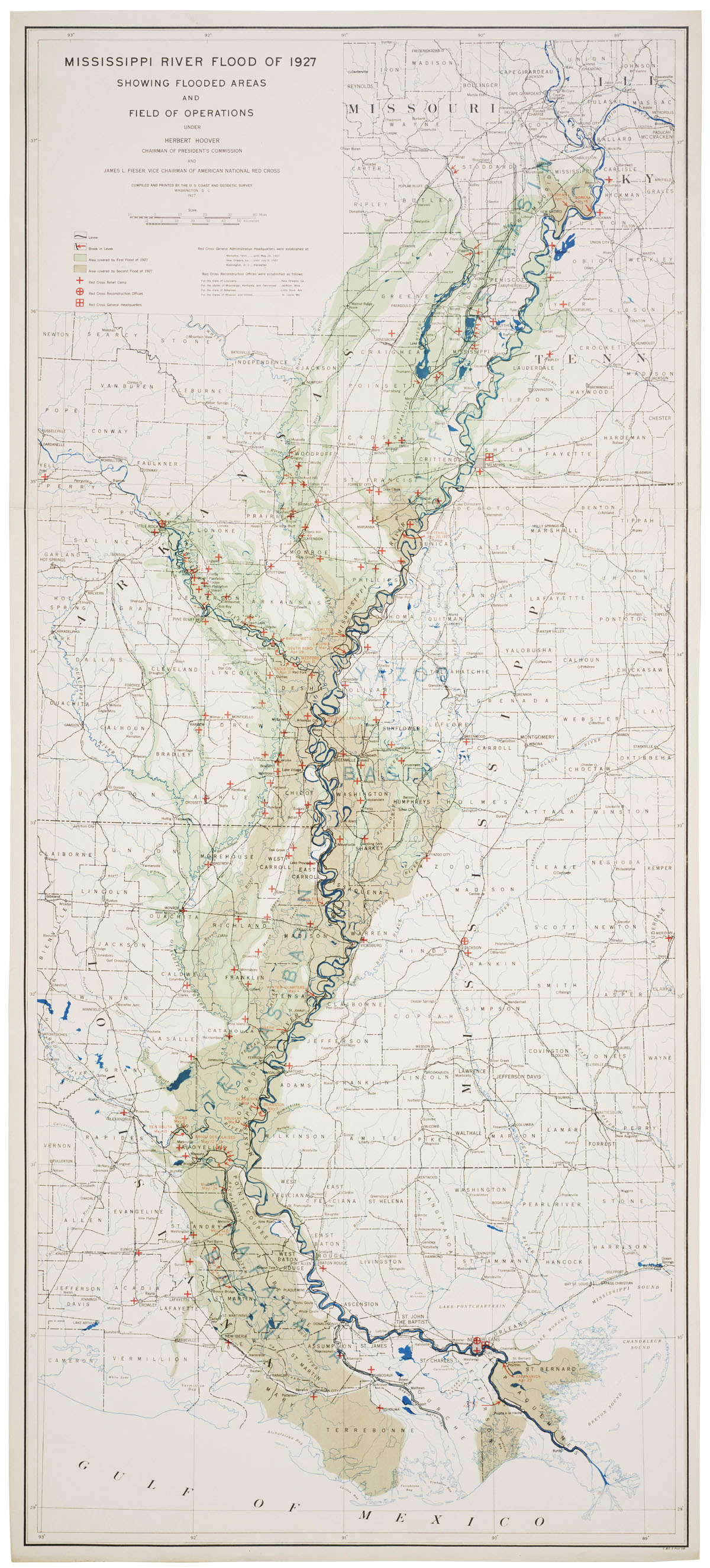
The Coast and Geodetic Survey was directed to map the history of the great Mississippi River Flood of 1927. (Records of the Coast and Geodetic Survey, RG 23)
The U.S. Coast and Geodetic Survey as such, ceased to exist. Nevertheless, all the traditional work of the Survey persisted, reorganized in a variety of offices and services within NOAA. It requires rigorous attention to a NOAA organizational chart to discern the deconstructed Survey among the myriad of NOAA boxes, but the Survey and its legacies show in NOAA's work. NOAA still produces nautical charts and predicts the tides, monitors the magnetic field of the earth and solar system, and maintains the geodetic network upon which all precise positioning on the North American continent is based.
The Survey of the Coast as such is gone, but its legacy is the full array of scientific agencies in the government. Those looking for the Survey may profit by the inscription in London's St. Paul's Cathedral concerning Sir Christopher Wren, the brilliant architect of the cathedral. His epitaph, translated from the Latin, states: "if you would seek his monument, then look around you." Hassler's legacy may be found from the depths of the oceans to the surface of the Sun.
John Cloud is a geographer working on contract to NOAA to research the history of the U.S. Coast and Geodetic Survey. He received his Ph.D. from the University of California, Santa Barbara.
Note on Sources
Hassler's Survey of the Coast became the Coast Survey, and then the Coast and Geodetic Survey, until the creation of NOAA. Record Group 23 incorporates the records of the Survey until 1970; NOAA's records are found in Record Group 370. In 1958 Nathan Reingold, then in the early stages of his distinguished career in the history of science in the federal government, published NARA Preliminary Inventory No. 105, Records of the Coast and Geodetic Survey. It remains an unparalleled introduction to the wealth of scientific and historical records of the Survey and its many roles in American and global science.
Until the advent of the National Archives, the Survey preserved its own records from the era of Bache onward in what evolved as the Library and Archives Collection. The Library and Archives Collection consisted of the scientific library of the Survey, the primary records of the Survey's work, including the original survey notebooks and sketchbooks, the original hand-drawn versions of nautical charts and other maps and charts produced and published by the Survey, an extensive archive of official photographs, dating back to 1865, as well as a vast map archive of important maps and charts and scientific graphics, such as reconnaissance sketches of seal-breeding beaches in the Pribilof Islands and hand-colored charts of ocean water temperatures, and much else. Eventually, in the 20th century, major dispersals of the Survey Library and Archives Collections began. The primary differentiation seems to have been between published books, which remained as the Coast and Geodetic Survey Library, and everything else, which were dispersed. Pursuant to the dictates of President Taft's 1910 Committee on Economy and Efficiency in Government, thousands of the elements of the Survey's map and chart collection were transferred to the Library of Congress. After World War II, almost all of the primary records of the Survey, and the historic scientific data and the photograph collections, were transferred to the National Archives. These now reside at the National Archives at College Park, Maryland, distributed between the Still Photography Division, Textual Records, and Cartographic and Architectural Records.
Meanwhile, the Coast and Geodetic Survey Library transferred into NOAA. When, in 1971, the legacy libraries of what had been the Coast and Geodetic Survey, the Weather Bureau, and the Bureau of Fisheries were combined, the resultant NOAA Central Library, now in Silver Spring, Maryland, became the largest open-stack collection of historic earth science materials on the planet. The NOAA Central Library is also a limited-scope federal depository library, which means that the library is open to all, apart from the collections assembled in the Rare Book Room, which are accessible by arrangement to qualified researchers.
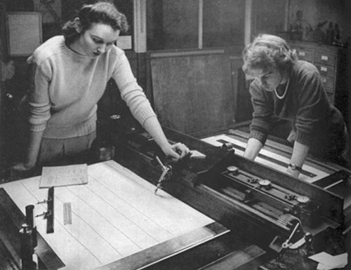
The Coast and Geodetic Survey published nearly 100 million maps for World War II. They all began as graticules, or map grid outlines, which were scribed on plastic vinylite sheets on the Survey's unique projection ruling machine. The machine, here operated by Barbara Clayton (left) and Patricia Hayes (right), was in constant use throughout the war. (NOAA Historic Coast and Geodetic Survey Collection)
The NOAA Central Library has become the primary conduit for access to the legacy assets of NOAA and its predecessor agencies. From the NOAA Central Library home page, users can access:
- Digital file versions of a wide variety of historic legacy documents, including annual reports of the Coast Survey, daily weather maps of the United States from their beginning in 1871, the annual reports of the U.S. Fish Commission, and much else.
- Digital files of some (but by no means all) of the historic maps and charts produced by the Coast Survey since the 1840s.
- Digital images of approximately 30,000 photographs in the NOAA Photo Library. These encompass thousands of historic photographs from the Coast Survey as well as historic and contemporary photographs covering NOAA activities and responsibilities, including marine sanctuaries, deep-sea ocean exploration, and much else.
Through NOAA's Climate Data Modernization Program (CDMP), many thousands of the best maps and charts from the Coast and Geodetic Survey Archives Collection at the National Archives are being scanned and will be made accessible digitally through these same NOAA historic sites referenced from the NOAA Central Library.
Histories of NOAA and its legacy agencies are accessible through the NOAA History Page and the NOAA Heritage Page.
Also, NOAA has developed a special web site specific to the 200th anniversary, with information on the histories and significance of all the legacy scientific agencies that now constitute NOAA, along with schedules of activities, exhibitions, and times and places when NOAA ships will dock and hold "open-ship" sessions so the public can see how Hassler's successors continue to map the coasts.