![]()
Plans of Division
Describing the Enumeration Districts of the 1930 Census
Fall 2003, Vol. 35, No. 3 | Genealogy Notes
By Claire Prechtel-Kluskens

Mapmakers are at work in the Geographer's Division in the years after the 1930 census, for which they produced 8,354 maps outlining each of the nation's 120,105 enumeration districts.
In preparation for taking the fifteenth decennial population census in April 1930, the Bureau of the Census divided the nation's fifty-six states, territories, and possessions into 120,105 enumeration districts (EDs).1 An enumeration district is an area that a single census taker could cover in two to four weeks, and it varied in size from one city block to an entire county in rural areas.
The practice of dividing up the country into manageable EDs has been around since the first census, in 1790. Since 1880, EDs have been numbered, and researchers look for that number to locate the residence of the person listed on the schedule within the larger community.
When the 1930 population census was released on April 1, 2002, the National Archives and Records Administration produced three finding aids to help researchers find their way through the schedules: the online 1930 Census Microfilm Locator, the microfilmed Enumeration District Maps for the Fifteenth Census of the United States, 1930 (M1930, 36 rolls), and Index to Selected City Streets and Enumeration Districts, 1930 Census (M1931, 7 rolls). These tools make individual ED details more widely and more easily accessible than such details were in the past. Because the serious researcher may be curious about how the bureau prepared for the census and why EDs are set up the way they are, this article will examine the principles upon which the Census Bureau established the ED boundaries.
Establishing the Boundaries
The Census Bureau did not begin the task of laying out ED boundaries from a clean slate. It had on hand the maps used in connection with the 1920 census, the written description (plan of division) of the 1920 EDs, and the corresponding population figures for each of the 1920 EDs. Even with this information, however, a large and daunting task remained. The nation's population had increased, particularly in cities, and there were a multitude of other changes: more city streets had been built; more cities and towns had been incorporated and some disincorporated; more rural land had been annexed into cities; and new institutions had been created while others had been discontinued. The bureau therefore had to take a fresh look at the ED boundaries and, above all, get the most up-to-date maps and information.
First, the bureau acquired maps of each county and of many of the towns and cities from federal, state, county, and private agencies. For some of the largest cities, the bureau made its own maps. Before and during the taking of the 1930 census, the bureau kept three full sets of enumeration district maps, of which the "office" set was accessioned into NARA.2 Because of the wide variety of sources from which these base maps originated, the quality varies from state to state and even among counties in the same state. There is little uniformity in map scale, size, or numbers of sheets.
Second, the bureau described each ED in what it called "plans of division." The plans of division were arranged by state, then alphabetically by county, then by local jurisdiction. Each plan indicates the 1930 ED number, describes the geographical limits of the included area, the population size, and the rate of enumerator's pay. Every page also notes the 1920 ED number for the same area and the actual number of 1920 farms or estimated number of 1929 farms. Five sets of the plans of division were typewritten simultaneously using carbon paper and bound into seventy-four volumes. Once the census was taken, the bureau annotated the plans of division in pencil or ink, noting the 1930 population for each ED and any additions or corrections, such as additional unincorporated places or institutions enumerated separately. One typescript set of the plans of division was accessioned into NARA and microfilmed as rolls 61 through 90 of Descriptions of Census Enumeration Districts, 1830 - 1950 (T1224, 156 rolls). As the written plans were finalized, the bureau annotated the ED maps with the boundaries and numbers of individual EDs, usually added in an orange grease or wax pencil. There are some 8,345 ED map sheets associated with the 1930 federal population census, and all extant maps were microfilmed in color as Enumeration District Maps for the Fifteenth Census of the United States, 1930 (M1930, 36 rolls).
Third, the bureau submitted the plans of division and related maps to the census supervisors for review. The supervisors checked the accuracy of the plans and recommended any changes they believed appropriate.3 The nation was divided into 575 supervisor's districts. Each supervisor hired the enumerators for his area and supervised the conduct of the enumeration.
Fourth, the Census Bureau made a "portfolio" for each enumeration district that included the plan of division and a map in addition to blank schedules and other necessary forms. If the enumerator found the ED map "incorrect in any detail," he or she reported the error to the bureau through the supervisor. In this way, changes may have been made to the bureau's maps and plans of division even during the course of the enumeration.4
Determining ED Boundaries
In determining the geographic bounds of each ED, the Bureau of the Census followed three general principles.
First, each ED would contain a single political subdivision, either a minor civil division (MCD) or an incorporated place. The bureau used the term "minor civil division" to describe the political subdivision unit below the county level (such as cities, towns, villages, precincts, and townships), since the name for that unit varies widely throughout the United States. According to the general "Instructions for Making Plans of Division," every incorporated place and unincorporated places with populations of more than 2,000 were designated separate EDs.
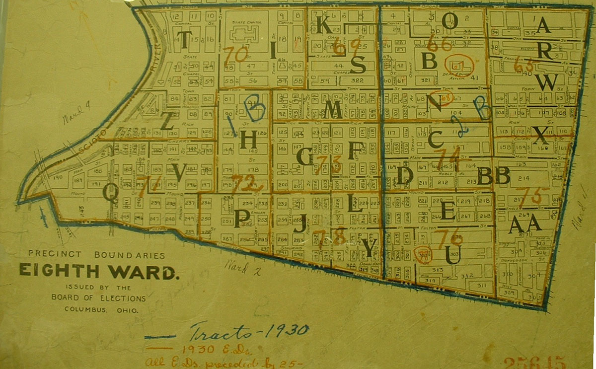
The Census Bureau used ward maps for larger cities, such as this Columbus, Ohio, map obtained from the local board of elections.
Second, each ED would be of a convenient size (in both geography and population) that would permit a single enumerator to complete his or her work within two weeks in cities and one month in rural areas. Because most incorporated places and MCDs were too large to be a single ED, they were divided into logical parts. For example, a city ED might consist of solely of one ward or one precinct, or perhaps two or three precincts from one ward. If the boundaries of an incorporated or unincorporated place crossed from one MCD into another, the part in each MCD would be a separate ED. It was better to make an ED too small rather than too large.
Third, certain institutions would be designated as separate EDs. These included army and navy facilities, U.S. Veterans Bureau hospitals, marine hospitals (these served merchant seamen), U.S. Public Health Service hospitals, state prisons and reformatories, insane asylums, institutions for feeble-minded persons, certain Roman Catholic religious institutions (motherhouses, novitiates, abbeys, and monasteries), and any institution that had been a separate institution in 1920. YMCAs or YWCAs were not made separate EDs regardless of size, but they were "shown separately" by enumerators, that is, shown on separate census enumeration sheets apart from the rest of the ED.
There were 27,370 enumerated institutions in the continental United States in 1930; of these, 3,195 were separate EDs. In addition, apartment buildings having more than one hundred units and large hotels having permanent residents would be separate EDs. Facilities that were not considered institutions for census purposes included child placing agencies, day nurseries, welfare bureaus, settlement houses, boards of children's guardians, or day schools. National parks were made separate EDs, but national forests were not, although enumerators were instructed to "show separately" any inhabitants.5
The bureau probably chose to adhere to political boundaries in order to make future multicensus comparisons of population trends more feasible. In fact, the 1930 census was the first census in which the bureau systematically chose to make each MCD or incorporated place into a single ED, even when the jurisdiction's population was relatively small or even zero. In comparison, for the 1920 and earlier censuses, the bureau frequently grouped several rural jurisdictions into one ED.
Numbering and Arranging EDs
The numbering and arrangement of enumeration districts evolved over time. For the 1790 through 1870 censuses, the EDs were not numbered and consisted of large areas that included many MCDs. For the 1880 through 1920 censuses, each county was divided into numbered EDs.
For 1930, the Census Bureau adopted a new numbering scheme. For fifty-one of the fifty-six states and territories, the ED number contains a prefix and a suffix. ED 17-1, for example, denotes the county number (17) and the smaller unit within the county (1). For five areas, however, EDs were numbered consecutively without a prefix (e.g., 1–47) throughout the entire jurisdiction (the District of Columbia, American Samoa, the Canal Zone, Guam, and the Virgin Islands).
Counties were assigned prefix numbers according to the alphabetical sequence of their names. Suffixes were similarly determined by the names of the smaller political subdivisions. The bureau called populated places cities, towns, villages, etc., according to each state's laws. For example, a state might require a populated place to have a minimum population to be qualified as a city, town, or village, and this minimum varied by state. The plans of division (written descriptions of EDs) follow five general patterns.6
1. All populated places were listed alphabetically without regard to type of jurisdiction. This arrangement was followed mostly in western states in which the entire county consisted of named and/or numbered MCDs and independent incorporated places.
2. Townships were listed alphabetically, if named (or numerically, if numbered). Cities or towns located within the bounds of the township would be listed first, then the balance of the township. This arrangement was followed for most of the United States.
3. Within cities, the wards or precincts, or parts thereof, were usually listed in numerical sequence.
4. Certain large cities, such as Los Angeles and the five boroughs of New York City, were composed of numbered assembly districts; these were not necessarily arranged numerically.
5. EDs were largely—but not entirely—listed in numerical order in the plans of division. The Census Bureau sometimes found it necessary to add EDs after the basic numbering scheme had already been determined, particularly in large cities that had experienced substantial population growth since 1920. One of the most extreme cases is Kings County (Brooklyn), New York, which has 1,953 EDs. The main sequence runs from 1 to 1472, with 1473 through 1953 interfiled among that series.
Describing EDs
The plans of division described the 1930 EDs using a standard format laid out by the Census Bureau. The format followed six basic principles.
1. The bureau used a "block-by-block" format to describe sixty-seven cities whose 1920 population was more than 100,000. This style of description is best shown by an example from Cleveland, Ohio:
18-111 Cleveland city—Ward 8—Part of Tract C-4
Part of Precinct E
Block 72 - Detroit Ave., W. 52nd, Franklin Ave., W. 54th
Part of Precinct K
Block 109 - Franklin Ave., W. 52nd, Bridge Ct., W. 54th
Block 110 - Bridge Ct., W. 52nd, Bridge Ave., W. 54th
Precinct O
Block 177 - Bridge Ave., W. 52nd, Duke Ave., W. 54th
Block 178 - Bridge Ave., W. 50th, Duke Ave., W. 52nd
Block 179 - Duke Ave., W. 52d, Lorain Ave., W. 54th
Block 180 - Duke Ave., W. 50th, Lorain Ave., W. 52nd
In this example, ED 18-111 is placed within census tract C-4. A census tract is "a small, relatively permanent statistical subdivision of a county or statistically equivalent entity, delineated for data presentation purposes."7 The streets forming each "block" are shown, beginning usually with a street on the northerly side of the ED and proceeding clockwise. A "street" was understood to be a "street" unless it was called something else, in which case the abbreviation for road, avenue, boulevard, court, lane, terrace, river, railroad, and so forth, would be given. The related ED map frequently shows the block numbers as well as ED numbers. Blocks may comprise more than four boundary streets, particularly in hilly cities, or a block may be triangular in shape and be described by only three boundary streets. Large cities were described in this way, according to Clarence E. Batschelet, head of the Geographer's Division, "to insure a more accurate census in that the local supervisors can readily check the enumerators' returns before they are sent to Washington." The enumerators noted each block number at the top of each census page and began each new block on a new page. Also, if ward boundaries changed, the bureau could easily reassign the affected blocks to the correct ward.8
2. The bureau described ED boundaries for cities with populations between 3,000 and 100,000 using roughly the north, east, south, and west boundaries by the name of a road, river, railroad, or other geographic feature. This style of description is best shown by this example from Ravenna, Ohio:
67-27 Ravenna city—Ward 4, bounded by—Main
City limits
City limits, N. O. T. & L. Co., City limits
S. Chestnut
3. The bureau usually described rural areas divided into two or more EDs in terms like these used for Barrington town, Bristol County, Rhode Island:
1-1 That part of Barrington town south of Providence, Warren and Bristol railroad from western town line to Barrington River, and west of Barrington and Warren Rivers
4. The bureau described known unincorporated places with populations of more than 500 by name. Those estimated to be more than 2,000 in population were made separate EDs. For those with populations of less than 2,000, enumerators were instructed to "show separately" such places, that is, to report them on separate census enumeration sheets and not "bury" them in the rest of the ED. For example, ED 67-1 in Portage County, Ohio, is described thus:
67-1 Atwater township
Show separately Atwater (unincorporated)
5. The bureau described institutions by name if they were a separate ED or if the enumerator was to report the institution's inhabitants on separate census enumeration sheets. The bureau sometimes noted the institution to be for "colored" or "negro" persons if it was not evident from its name. These examples of institutional listings come from Ross County, Ohio:
71-28 Federal Reformatory and U.S. Veterans Hospital No. 97
71-31 Union township
Show separately Ross County Infirmary
Lighthouses and lightships were never made into separate EDs, but because many enumerators listed them separately from the rest of the ED, the bureau annotated the plans of division upon completion of the census to note this fact.
6. The bureau described Indian reservations as separate EDs in some cases but not in others. Separate EDs were pueblos in New Mexico, unallotted reservations, allotted reservations that were in more than one minor civil division or had more than two hundred inhabitants, restricted reservations in unorganized counties (primarily reservations allotted but not open to the public, still being tribal lands), and restricted reservations covering a large territory or having more than two hundred inhabitants. Some standard enumeration districts included Indian reservations whose inhabitants were to be "shown separately" on the schedules, such as Mission Indians in California and reservations that were open for settlement and allotted.9
7. The bureau described a few EDs in the plans of division as being solely for crews of vessels and, following the completion of the census, annotated other EDs as being ones in which there were crews of vessels. However, crews on U.S.-flag vessels were enumerated using different schedules and different procedures from those used on land. For more information about these schedules and the procedures by which they were taken, see 1930 Census of Merchant Seamen (M1932, 3 rolls).
1930 Census Microfilm Locator
The 1930 Census Microfilm Locator, online at http://www.archives.gov/research/census/1930/, is a fully searchable database that links geographic descriptions and many named institutions to the appropriate ED number and microfilm roll number.10 Using the locator, researchers can search by state, county, township, institution, or other place name to identify the ED in which the subject of their research resided in 1930. Because the census schedules for only twelve states have Soundex name indexes, knowing the ED is crucial to finding individuals in the 1930 census. The geographic data in the locator is an edited version of the approximately twenty thousand typewritten pages of the plans of division reproduced rolls on 61–90 of Descriptions of Census Enumeration Districts, 1830–1950 (T1224, 156 rolls).
When performing a search in the online locator, remember that most city descriptions include only the boundary streets for the district. Visual ED description is provided by Enumeration District Maps for the Fifteenth Census of the United States, 1930 (M1930, 36 rolls), and additional help is provided by the Index to Selected City Streets and Enumeration Districts, 1930 Census (M1931, 7 rolls), which provides the exact ED number(s) for street addresses in selected cities as well as ED numbers for unincorporated places in North Carolina. The web site "Obtaining EDs for the 1930 Census in One Step (Large Cities)" at www.stevemorse.org/census/ by Stephen P. Morse, Joel D. Weintraub, and David R. Kehs, provides a database to determine the exact ED for an address if the nearest cross-streets are known. The commercial web site Ancestry.com provides (by subscription only) search capabilities by personal name and other criteria.
These few pages have given some insight into one significant aspect of the Census Bureau's preparation for enumerating the U.S. population in 1930. This work built upon the bureau's institutional knowledge of the planning and execution of the 1920 census. In turn, the work for 1930 would form a basis for planning and executing the 1940 census. And so it would go . . . on down to the most recent census in 2000.
NOTES
All of the records discussed here are from the Records of the Bureau of the Census, Record Group (RG) 29; National Archives and Records Administration, Washington, D.C., and are described (except Accession NN3-29-90-2) in Katherine H. Davidson and Charlotte M. Ashby, Preliminary Inventory (PI) No. 161, Records of the Bureau of the Census (Washington, DC: National Archives, 1964, reprinted 1997). The "Series" numbers noted in these footnotes refer to those used in PI 161. In addition, the Annual Report of the Director of the Census to the Secretary of Commerce for the Fiscal Year Ended June 30, 1930 (1930) and Instructions to Enumerators: Population and Agriculture (1930) also provided valuable information.
In addition to other items cited below, most of the detail is from the Subject File, 1889–1950 (Series 160), box 65. There is a folder, "Instructions—1930 Census" with several useful items: 1) Untitled note by L. Koehne (1 page, undated); 2) "Instructions for Making Plans of Division—1930 [General]" (9 numbered pages, undated); 3) "When Plans are Returned from Supervisor" (1 page, undated); and 4) "1930 Instructions for making plans of division [cities]" (4 unnumbered pages, undated). Also, an envelope, "Instructions 1930 Census (West)," being files kept by a Miss West, contains "Minor Civil Divisions—1930" (one page, undated) and Untitled [First page headed "Enumeration District Numbers"] (3 pages, undated). Finally, there is also contains an envelope, "1930—Instructions regarding Indian Reservations/Scheme for Binding Population schedules," which contains the "Instructions Regarding Indian Reservations and National Parks" (1 page, undated).
1 The fifty-six jurisdictions were the forty-eight continental states, District of Columbia, territories of Alaska and Hawaii, American Samoa, Canal Zone, Guam, Puerto Rico, and the U.S. Virgin Islands. About 1,700 EDs were outside the continental United States. The official census day was April 1, 1930, except in Alaska, where it was October 1, 1929. In the continental United States, 1,325 EDs that had no population, and 135 ED numbers were assigned but then not used ("void"). See "Enumeration Districts: 1930," Folder, "Enumeration Districts, 1930," box 15, Geography Division Correspondence, Geography Division, Accession NN3-29-90-2, National Archives Building.
2 L. Koehne refers to three sets upon which the bureau made annotations. The maps in NARA custody frequently have the word "OFFICE" stamped upon them, indicating that they are part of the Central Office set and not a set used in the field by supervisors or enumerators.
3 Bureau of the Census, Instructions to Supervisors [Revised] (Form 15-13a), pp. 6–12 (1930); copy in File "740: Instructions to Supervisors, 1930," Numbered File of Schedules, Forms, and Instructions, 1900–40 (Series 212). Paragraphs 29–43, 45–49, and 53–54 are most pertinent.
4 Bureau of the Census, Instructions to Enumerators, Population and Agriculture [Revised] (Form 15-100), p. 2 (1930).
5 "Number of Institutions: 1930," folder "Institutional Work," box 4, Geography Division Correspondence, Accession NN3-29-90-2; also "1930 Instructions for making plans of division [cities]"; and "Instructions Regarding Indian Reservations and National Parks."
6 For details, see "Instructions for Making Plans of Division—1930 [General]." Early drafts of this document are in the envelope entitled "Instructions 1930 Census (West)." See also Untitled [First page headed "Enumeration District Numbers"], which provides a little more insight into the processes for ED numbering and for making changes in the plans of division. Miss West's lists of cities over 100,000 population [in 1920] for unknown reasons omit San Antonio, TX; Seattle, WA; Syracuse, NY; Toledo, OH; Washington, DC; Worcester, MA; and Yonkers, NY.
7 For details on census tract definitions in 2000, see "Geographic Changes for Census 2000 + Glossary" online in 2003 at https://www.nrc.gov/docs/ML0701/ML070170591.pdf.
8 Clarence E. Batschelet, Geographer, "Memorandum for the Director," Aug. 24, 1928, File "Geographic Work," box 17, Geography Division Correspondence, Accession NN3-29-90-2.
9 "Instructions Regarding Indian Reservations and National Parks."
10 Constance Potter (NARA staff, Washington, DC) was the roll list editor. Claire Prechtel-Kluskens (NARA staff, Washington, DC) was the geographic data editor. Ms. Kluskens is grateful for the generous assistance provided by Jean Nudd, Jean Kubica, Ellen McMahon, and William Murphy (NARA staff, Pittsfield, MA); Mary Bazinet, Charlotte Davis, Arlene Jennings, Pauline Mezzack, Jean Salzarulo, Rose Senger, Viola Sivik, Kathleen Stottle, and Ruth Whitney (NARA volunteers, Pittsfield, MA); William G. Stewart, Tracee Hamilton, Nicole Gilkison, Fred Matthies, William Plunkett, and Ray Zanin (NARA volunteers, Washington, DC); Sue McDonough and Tawana Pleasure (NARA staff, Washington, DC); and for the courtesies extended by current and former staff of the Cartographic and Architectural Branch of the Special Media Archives Services Division (NARA, College Park, MD), including but not limited to Robert Richardson, Richard H. Smith, Henry Gwiazda, Raymond Cotton, Sam Welch, Linda Cullember, Daryl Bottoms, Patricia Young, Gerald Luchansky, Deborah Lelansky, Dan Jansen, and Jennifer Nelson.