![]()
The Alaskan Frontier in Panorama
How the National Archives Preserved Early 20th-Century Photographs
Winter 2009, Vol. 41, No. 4
By Richard E. Schneider
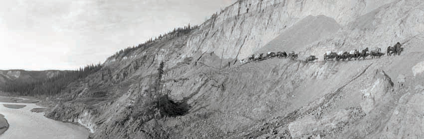
A pack of train horses carries supplies for the surveying team in Alaska, ca. 1915. (57-N-Miscellaneous-82-4)
Alaska is one of the most beautiful and fascinating places on Earth. For the photographer, it presents limitless possibilities for artistic pursuits, so long as one is not deterred by occasional extreme weather conditions, inhospitable terrain, and the isolation one can experience in such a vast land.
From 1911 to 1932, the United States Geological Survey (USGS) created a large body of panoramic photographs (approximately 5,000) of various regions in the Alaska Territory. At first glance, these images appeared to simply provide a visual record of scenic locations. Upon further examination however, we learn that these panoramas had a far different intent, namely as visual aids in topographic surveying.
The selection of images reproduced here is dominated by those of Alaskan glaciers. In recognition of the effects of climate change in our modern times, it seems appropriate to showcase these unique geological features, many of which are now in a state of retreat.
In certain circumstances, the panorama is composed from separate still frames. This was achieved using digital "stitching" software that can seamlessly combine two or more images into one expanded scene. While some of the panoramas appeared as illustrations in USGS Bulletin 657 in 1917, most of these spectacular photographs have never been seen before by the general public.
In the early 20th century, rigid glass plate negatives used in photography were quickly being replaced by what was termed "flexible film." Instead of the light-sensitive emulsion being coated onto separate glass panes, it would be adhered to a long, continuous plastic film base. This film could be wrapped onto rolls, enabling the photographer to take numerous pictures before having to change out the exposed roll for a new film cartridge. Photographers were no longer constrained by one-at-a-time picture taking. This would revolutionize photography.
The only problem with the original flexible film was its chemical composition. The prevailing technology used a film base of nitrocellulose (an ingredient found in guncotton). This compound was indeed flexible, and it did open up a world of possibilities for photographers and camera designers. But under the wrong conditions—warm temperatures, high humidity, and poor ventilation of storage space—nitrate film had the potential for combustion. In fact, "nitrate fires" would become a dreadful and all-too-common occurrence in cinemas, film storage facilities, museums, and archives well into the 20th century. While acknowledging the serious risks posed, the advances in creativity and scientific knowledge made possible by flexible nitrate film cannot be understated (nitrate film would gradually be replaced industry-wide by cellulose acetate, or "safety" film base).
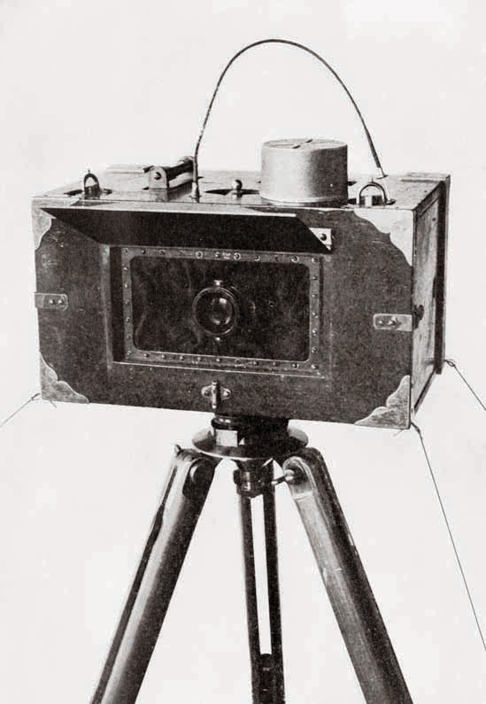
This panoramic camera was designed by the USGS and used 5" or 6" wide roll film. (Records of the U.S. Geological Survey)
Alaska in the early 20th century was a distant and exotic territory brimming with gold, timber, minerals, and sea life. The USGS, along with other federal agencies, was responsible for surveying and mapping the terrain in part so that entities, such as the Alaska Railroad (which began operation in 1903), could safely and efficiently bring necessities to the vast interior and enable the land's riches to be exported to the lower 48 states and beyond.
Alaska was a dangerous place to conduct surveying expeditions, in no small part due to the fact that, aside from fledgling railroad companies, little transportation infrastructure existed. Add to that the impracticality of surveying in any season other than summer, and you have the challenge of having to record the topography of a vast and varied landscape in a short amount of time without any easy method for getting from point A to point B.
In response to these constraints, the USGS employed an ingenious panoramic camera system. Developed for the USGS by C. W. Wright in 1904, the camera itself was modeled after the Al-Vista, a commercially manufactured panoramic camera whose invention and patents dated back to 1898.
The Al-Vista exposed flexible roll film by means of a slit (about one-quarter inch wide) located behind the lens. The lens was mounted in such a way that it pivoted from one side to another (hence the name "swing-lens" camera). As the lens turned, light would strike the film through the slit. Film was not held flat by the camera body (as with a modern 35mm camera) but instead followed an arc. An image taken by an Al-Vista model 5-B, for example, would be 5" x 12" in size with a 140-degree angle of view.
In addition to the panoramic camera, the field equipment system often included the plane table (for the surveyor to make sketches in the field) an adjustable panoramic photo-alidade (to measure and map the distances between geological objects), and a theodolite (to determine latitude and longitude).
The USGS surveyor most closely associated with the development and use of the panoramic camera system in Alaska was Maj. James W. Bagley. In 1917, Bagley wrote USGS Bulletin 657, The Use of the Panoramic Camera in Topographic Surveying. In retrospect, the history, justification, technical information, documentary evidence, and mathematical formulas found in this bulletin make it one of the most important publications ever produced on the scientific uses of the panorama. While most swing-lens panoramic cameras were used for scenic or group shots, Bagley found a way to use it for precise topographic measurements that would be used by geographers during this crucial period in Alaska's history.
Among the most interesting information in the bulletin is Bagley's cost-benefit analysis. Bagley was devoted to obtaining the greatest amount of product for the lowest price. The "product" in this case was visual documentation, in photographs, of those Alaskan regions thought to be most important for the USGS and other stakeholders. Under normal circumstances in the lower 48 states, precision fieldwork (hand-sketching using a plane table) could be laborious and time consuming, and therefore expensive. By contrast, photographs of a similar caliber could be produced much more quickly to satisfy demand for certified topographic maps.
Despite the obvious advantages of flexible film, glass plate negatives were still widely available in the commercial marketplace. Creating a panoramic vista from a combination of separate, still photographs printed from glass plates was common practice and was indeed considered by Bagley when he turned his sights toward Alaska. He determined, however, that the cost of transporting heavy glass plates would negate by far the benefits offered by a prevailing and proven technology. Bagley took a big chance, out there in the wilderness, with a customized camera system and film stock that, though inexpensive to transport and versatile in its applications, left some questions to be answered.
The task of photographing in the Alaskan frontier meant that the party had to bring everything with them from the nearest settled town or city. They traveled by boat or by pack train (horses). The total number of surveyors ranged from seven to ten, depending on their assignment from USGS. They processed the film and reviewed the photographs in the field. Often the information contained in the photograph would be supplemented by sketches. A given geographical area would be divided into "stations" where the panoramas would be taken. An average day's production might be four panoramic images shot at each of three stations. Often the photographer would intentionally overlap two to four exposures, each taken from a different vantage point on the camera's axis. When combined, or simply viewed one atop the other, they would form an expanded 360-degree panorama.
Major Bagley was by no means the only USGS surveyor in Alaska using the panoramic camera. He was simply the most prolific, influential, and technically astute photographer the USGS had in these remote locations. His panoramic legacy may have been embodied and preserved in USGS Bulletin 657, but even as this went to press, Bagley had his sights set elsewhere. The last chapter of this 1917 bulletin discusses "the Application of Photogrammetry to Aerial Surveys." Even as panoramic land-based photography would continue at the USGS until at least 1932, Major Bagley already had his surveyor's eye trained at the skies and to the potential of aerial photography.
The panoramic negatives and prints taken by Major Bagley and the others associated with this project eventually found their way to the USGS Photographic Library in Denver, Colorado. The danger of nitrate film, however, posed a storage problem for the USGS.
Long-standing federal regulations mandated that agencies themselves duplicate nitrate film materials deemed permanent by the National Archives. These duplicates would then become part of the Archives' holdings. If an agency wished to retain originals deemed disposable by the Archives, it would have to follow guidance on proper storage. In the early 1980s the USGS began a duplication effort for their collection of about 87,000 nitrate negatives. Most of these originals had been shot in the lower 48 states and were not in a panoramic format. However, because of conflicting priorities and a lack of funding, the duplication project eventually ground to a halt. By 1997, about 52,000 nitrate negatives remained to be duplicated, and it was acknowledged that the storage facility in Denver, with only minimal environmental controls, was inadequate for any long-term storage. It was determined that the best solution to this problem was to transfer the original negatives to the National Archives.
In March 2007 the USGS transferred the nitrate negatives to the Still Picture unit of the National Archives at College Park, Maryland. The film was loaded into fireproof metal storage units, which themselves were stored in a walk-in refrigerator kept at 38˚ F. The Special Media Preservation Division was given responsibility for duplicating the original film before the nitrate film was to be removed from the building.
The vast majority of the USGS nitrate negatives were standard 4" x 5" or 5" x 7" sizes. The preservation laboratories could duplicate these using existing proven photographic methods. The panoramic negatives required a new technique.
The panoramas, because of their size (5" x 12" and 6" x 12"), could not be duplicated using the optical camera system that had been used for the smaller film formats. After considering several possibilities, it was suggested that the laboratories use an aerial roll-film contact duplicating system dating from the 1950s. The result would be a duplicate negative created directly from the original negative. Each exposed and processed roll would be 10 inches tall by about 500 feet long and would contain about 400 duplicates. These could be cut into individual sheets at a later date.
The next step was to examine and prepare the nitrate negatives for duplication. The majority of the originals had only a minor degree of deterioration (mostly warping of the film base). Negatives with advanced stages of deterioration, however, had whole sections missing, as the film emulsion containing the image disintegrated. Other times the film base had cracked into jagged pieces and fallen off. There were also hundreds of negatives that had gotten wet decades ago and were either stuck together or had mold damage. Because the time permitted for the project did not allow for these images to be painstakingly treated, they did not get duplicated.
The roll-film contact apparatus was an easy and proven system for duplicating aerial film, or any large format film for that matter. Therefore, the process for duplicating the Alaska panoramas was straightforward, and the deadline for duplicating the USGS nitrate film was met. This was a special and significant project for the Special Media Preservation Division and was an excellent demonstration on how different units within the National Archives work together and rise to the occasion when important situations warrant.
The National Archives contains an indescribable wealth of original source material that cannot be found anyplace else. The investigation of these unique images turned up intersecting records from cartographic, textual and still picture holdings and relied on institutional knowledge from archivists who have many years' experience at this agency.
The dedicated work of the National Archives staff in preserving and making accessible these panoramic images in new formats provides an invaluable record for those interested in the physical history of Alaska as well as in the use of photography for scientific research.
Note on Sources
Other USGS surveyors who utilized the panoramic camera included E. O. Blades, W. G. Carson, C. E. Griffen, R. K. Lynt, and R. M. Wilson. The USGS did not identify the first and middle names of these surveyors either on the maps created using their data or in Bulletin 657.
Patent drawings of the Al-Vista Camera, and numerous other panoramic cameras, can be found at the National Archives in Records of the U.S. Patent and Trademark Office, Record Group 241.
For those wishing to see another historic example of panoramic photography being used for scientific purposes, please visit the Smithsonian Institution's web page to see "Beauty in Service to Science: The Panoramic Photographs of Charles D. Walcott." Michael Horsley of the Special Media Preservation Division, one of the contributors to this article, was an integral part of the research and production of this web page and the excellent photographic exhibition that preceded it (2004). The author also wishes to acknowledge the contributions to this article of other National Archives staff members: Joseph Schwarz, Ann Seibert, Sara Shpargel, Richard Smith, and Nicholas Natanson.
Richard E. Schneider, a management and program analyst in Preservation Programs of the National Archives, participated in the preparation and duplication of the USGS panoramic nitrate negatives in 2008. He curated "The Long View," an exhibit of historic panoramas and associated records from the National Archives on display at College Park, Maryland. A related article appeared in the fall 1997 issue of Prologue, and he also contributed to the online panoramic exhibit.