![]()
Maps at NARA of interest to Genealogists
The National Archives and Records Administration (NARA) has custody of over 5 million maps. Maps and related cartographic records are often useful for genealogical research. They can:
- provide important information on place names and localities at the time the maps were created
- show changing political boundaries, counties and minor civil subdivisions
- sometimes include names of individual land owners or residents.
The following cartographic series have particular significance to genealogists and may be used in the Cartographic and Architectural Research Room of the National Archives in College Park, MD.
Census:
-
Census enumeration district maps were prepared by the Bureau of the Census decennially from 1880 to 1970. They consist of approximately 110,000 printed, photocopied, and manuscript maps of cities, counties, lesser political units, and unincorporated areas. Only three maps exist for 1880, but the number of available maps increases with each succeeding census. The maps, arranged alphabetically by name of state, and thereunder by name of county and locality, are in Record Group (RG) 29, Records of the Bureau of the Census. Genealogists using the later 19thand early 20th-century censuses will find that knowing the enumeration district for a particular town or other political unit will make access to the population schedules easier.

1950 Census Enumeration District Map for Apache County, Arizona
- Enumeration district descriptions, 1850-1950, are also useful. From 1850 to 1870, the Bureau of the Census collected data according to two designated units, the district and the subdivision. The district usually corresponded to a state or part of a state, and the subdivision corresponded to a county or a part thereof. Beginning with 1880, the smallest unit was redesignated as the enumeration district, which corresponded frequently to a minor civil division.
- Civil division outline maps among the records of the Bureau of the Census are approximately 500 printed and annotated maps of the United States and individual states from 1920 to 1970. They show county or municipality and minor civil division boundaries and names and locations of incorporated places. They are arranged chronologically, thereunder alphabetically by state.
What's Online in the National Archives Catalog?
General Land Office Records
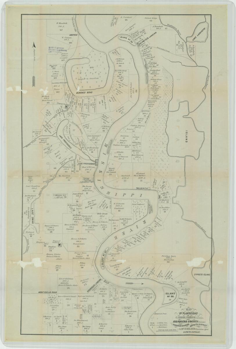
Map of Plantations in Carrol Parish, Louisiana, and Issaquena County, Mississippi. Goodrich Division, Skipwith District
What's Online in the National Archives Catalog?
Military Records
Manuscript, annotated, and printed maps, plans, and charts were compiled or collected by various military organizations, ca. 1770-1960. Of foremost importance are those among the Records of the Office of the Chief of Engineers, RG 77, the organization responsible for most of the military mapping pertaining to civil works, exploration, military campaigns, and fortifications in the United States during the 18th, 19th, and 20th centuries. Map coverage is most heavily concentrated in, but not limited to, areas of substantial Federal activity. Notable are detailed area and county maps of parts of Arkansas, Georgia, Louisiana, Maryland, Texas, and Virginia during the 1860s; maps of colonies, states, and territories; city plans; and maps of canals and roads. These records are usually arranged by state or region (by subject for canals and roads), and thereunder primarily chronologically. These records frequently indicate roads, canals, and waterways that could have been migration routes. They may include the names of residents, boundaries of civil divisions, inns, mills, churches, mountains, and other cultural and physical features.
Other records of particular interest to genealogists are those of the Army Graves Registration Service among the Records of the Office of the Quartermaster General, RG 92, and the Records of the American Battle Monuments Commission, RG 117. These maps, plans, diagrams, and tables provide the names and service numbers of some of the U.S. military personnel from both World War I and World War II who are buried overseas. The records are incomplete and unindexed for the purpose of locating individual names, but they do provide the locations of and plans for specific cemeteries. In addition, there are a limited number of similar records covering some Civil War cemeteries in the South for Union dead and a few Confederate soldiers. Only a few names of individuals are provided in these Civil War records.
What's Online in the National Archives Catalog?
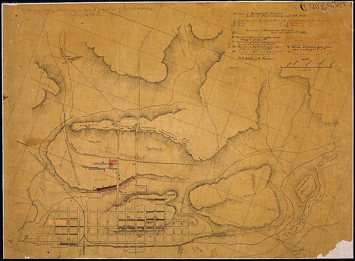
Positions of Humphreys' Division, Battle of Fredericksburg, Decr. 13th...[and] Decr. 14th, 15th & 16th, 1862.
Other Cartographic Records of Genealogical Interest
- The Department of Agriculture prepared and published small scale civil division maps of the United States decennially for the years 1840-1900. Similar maps are also available for 1909, 1915, 1920, 1931, 1935, and 1940. These maps indicate county boundaries and names as they then existed within all states and territories of the continental United States. During the 1930s, approximately 2,200 civil division maps spanning the period 1789-1932 were prepared in conjunction with a Work Projects Administration (WP A) study known as the Atlas of Congressional Roll Calls.
- Regional and state postal route maps in the Records of the Post Office Department, RG 28, are dated 1839-1960. Rural delivery route maps cover the period 1900-37. State and regional postal route maps show county names and boundaries, post offices and delivery routes, and distances and frequency of service between post offices. Names of individuals are sometimes shown on rural delivery maps.
- The Geological Survey records contain manuscript and published topographical quadrangle maps, 1888-present. They indicate extensive cultural and physical features such as county and township names and boundaries, towns, roads, railroads, houses, schools, churches, cemeteries, mountains, valleys, streams, and lakes.
Learn more about Cartographic Records at the National Archives