![]()
Aerial Photography at the National Archives at Riverside, California
Contact Information for NARA at Riverside
Record Group 18: Land and Building Files, ca. 1925 - ca. 1935
This series primarily contains military memorandums and reports concerning the history of land acquisition, infrastructure development, construction projects, and the operations of the Army Air Base at Rockwell Field - North Island in Coronado, California. Included in the files are associated supplemental maps and drawings showing aerial views of the base, or portions of the base, with illustrations of buildings, barracks, the landing field, water lines, sewage lines and other installations. The Commanding Officer at Rockwell Field generated and received many of the memorandums in this series. Frequent correspondents with the Commanding Officer include officials in the Adjutant General's Office, the Office of the Chief of the Air Corps, and Commandant of the Eleventh Naval District in San Diego.
Record Group 48: Boulder Canyon Project Histories, 1948 - 1966
This series contains histories, which include photographs, data tables, maps, and technical drawings, that describe projects authorized under the Boulder Canyon Project Act, namely Boulder Dam (later renamed Hoover Dam), Boulder Power Plant, located on the Colorado River, and the All-American Canal, all Bureau of Reclamation projects. The histories include information on project construction, operation, and maintenance, including the installation of power plant machinery. The records document the creation and construction of Boulder City, Nevada, and Lake Mead National Recreation Area. This series is partially digitized.

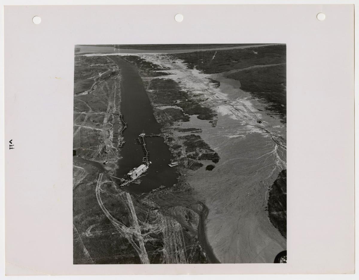
Record Group 48: Colorado River Project Histories, 1954 - 1965
This series contains annual project histories, which include data tables, sites plans, and photographs, of the Colorado River Project, a Bureau of Reclamation project. The histories document the construction, operations, and maintenance of a navigable channel, levees, and river front areas on the Colorado River. This series is partially digitized.
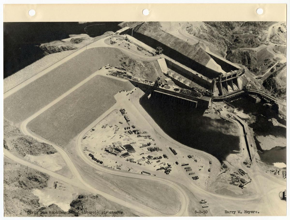
Record Group 48: Davis Dam Project Histories, 1948 - 1952
This series contains annual histories, which include photographs, maps, site plans, and technical drawings, of Davis Dam, originally called Bullishead Dam, a Bureau of Reclamation project, located in Pyramid Canyon on the Colorado River. The histories provide information on the construction, maintenance, and operation of the dam and power project. After 1952 the project was combined with the Parker Dam and Power Project and the annual histories of the two projects were combined. There are no histories for 1942 to 1946 due to work being halted on the project during World War II. This series is partially digitized.
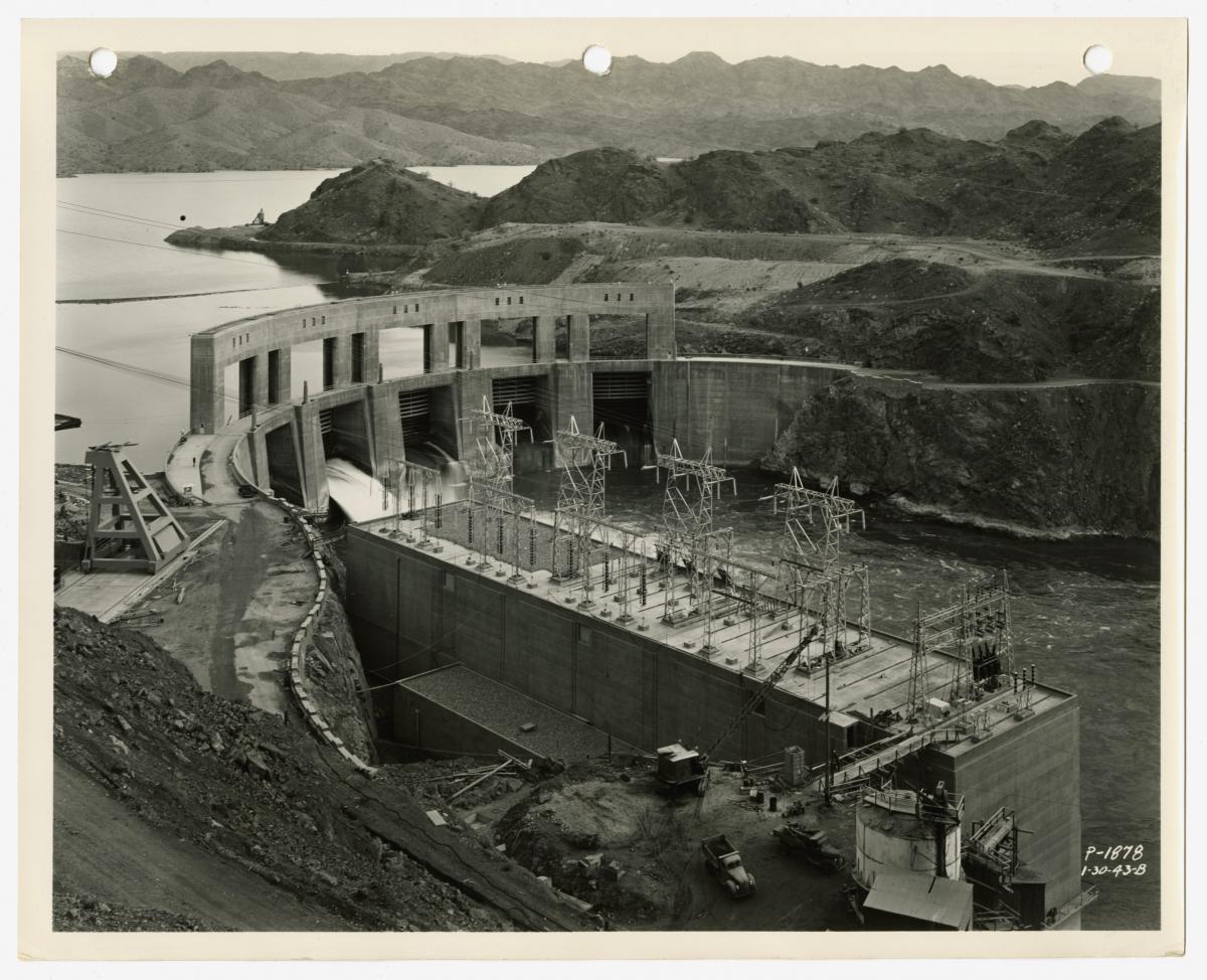
Record Group 48: Parker Dam Project Histories, 1948
This series contains histories, which include photographs and maps, of the Parker Dam Project, a Bureau of Reclamation project, located on the Colorado River. Included in the combined 1934-35 project history is a narrative of events concerning the termination of construction in 1934-1935 because of disagreement between the State of Arizona and the U.S. Army Corps of Engineers. The case was ultimately decided by the U.S. Supreme Court in favor of Arizona. This series is partially digitized.
Record Group 49: Aerial Photographs for Forage Surveys, 1954
This series contains aerial range survey photographs of Delamar, Panaca, Tule, and Clover Mountain units. The photographs correspond to some of the surveys in the series "Forage Inventory and Survey Sheets, 1957-1965" (National Archives Identifier 5106154).
Record Group 49: Grazing Range Studies, 1936 - 1965
This series consists of grazing range studies. These studies contain information on plant lists, soil conservation, range progress and improvement, plant development, range vegetation, grazing use, seeding trails, and precipitation. This series contains various types of records including reports, surveys, compilation sheets, range management plans, aerial and other photographs, maps, diagrams, graphs, correspondence. Most of the records relate to either the Crystal Springs or Panaca conservation unit.
Record Group 49: Records Relating to Statistical Inventories and Forage Surveys, 1953 - 1968
This series contains statistical analysis of land inventories and surveys. The series consists of a Forage Value Table which includes a Proper Use Table; Two-Phase Range Resource Condition Surveys; Annual Summaries of Forage Production, Range Use, and Range Condition; Two-Phase Range Condition Field Records, and Forage Inventory Field Write-up Sheets. Information may include the following information: state and district; date; examiner; unit or allotment; present use; traverse route; present range-resource condition index; description of type; description of site; forage stand; site-soil mantle; two-phase rating; unit or allotment summary; supplemental information; acreage-federal range; season of use; number and kind of livestock permitted; forage production circumstances; range use circumstances; range condition and trend record. Associated aerial photographs are found at the end of the series. Related series include: "Aerial Photographs for Forage Surveys", 1954-1954 (NAID: 5106147); and "Forage Inventory and Survey Sheets", 1956-1967 (NAID: 5106154).
Record Group 57: Field Geology Photographs of the Chief Scientist, Harold Masursky, 6/27/1953 - ca. 1971
This series predominantly consists of numerous photographs along with index cards and sixteen bound books mostly relating to Harold Masursky's field observations during part his employment at the United States Geological Survey (USGS). The photographs include aerial views of mountains and close-up shots of different rock formations in the Cortez Quadrangle of the Cortez Mountain Range and nearby Horse Creek Valley in central Nevada. The aerial photographs have handwritten geological notations marking significant features and geological boundaries. The non-aerial photographs are numbered; 1 - 556, and some have captions naming or describing the rock formations with geographic and geologic time period information. The index cards are numbered; 376 - 500. Each card relates to a specific observation made during field work in the Cortez Quadrangle with rock type and geographic information. However, the cards do not discernibly serve as an index to the aerial or non-aerial photographs in the series.
Record Group 75: Central Classified Files, 1920 - 1953
This series contains correspondence, reports, newspaper clippings, and other documents divided into the following categories: general and statistical; administration and control; finance and accounts; lands; buildings and building equipment; supplies and farm stock; military activities; health and social relations; education; industries and employment; roads; and Emergency Conservation Work (ECW) and Civilian Conservation Corps-Indian Division (CCC-ID) projects. These records document nearly all facets of agency operations as well as the administration of the reservations under its jurisdiction. The finding aid for the series is available at NARA at Riverside. This series is partially digitized.
Record Group 95: Aerial Photographs, 1953 - 1970
This series contains aerial photographs of the San Bernardino National Forest. Typical photographs include dates taken and coordinates or physical locations. Some of the photographs document fires in the forest and include names of fires; and dates and times the images were captured.
Record Group 95: Fire Records, 1956 - 1963
This series consists of correspondence, maps, reports, notes, analysis reports, radio logs, daily logs and diaries, photographs, aerial photographs, requisitions, news clippings, organizational charts, and weather forecasts relating to the Cat, Colter, Salthouse, and Valley fires. The maps in this series detail the origins, dates, and areas burned during each fire. Daily logs and diaries include name of forest; name of station; name of guard on duty; date; time of log entry; weather conditions including wind, wind direction and wind velocity, precipitation, temperature, humidity; time of incident; messages; and digest of conversations and observations. Radio logs include name of station, time of log entry, name of radio operator, and synopsis of message received or sent.
Record Group 95: Records of Project Flambeau, 1963 - 1966
This series consists of aerial photographs, correspondence, maps, charts, photographs, studies, reports and memorandums relating to a segment of Project Flambeau. In this segment of Project Flambeau, a joint project, titled Project 2521E, between the Forest Service, the Office of Civilian Defense and the Defense Atomic Support Agency of the Department of Defense was developed to study and understand the behaviors and effects of mass fires for the purpose of limiting destruction of communities adjacent to forests by fire in the event of a thermonuclear attack. The information included in the records cover test fires and studies in various national forest locations in California and Nevada and document various effects of fire behavior based on types and conditions of fuels; temperatures; ignition sources; and environmental conditions such as weather patterns and wind speed and direction. The finding aid for the series is available at NARA at Riverside.
Record Group 95: Timber Management Plans, 1952 - 1990
This series contains materials relating to the timber management process in the Angeles, Cleveland, Los Padres, and San Bernardino National Forests. Typical files may include correspondence, memorandums, reports, raw data, maps, charts, inventories, aerial photographs, and diaries. The records relate to timber management efforts in the Barton Flats, Bluff, Cold Water Canyon of Stockton, Camp Angeles, Crab, Deep Creek, Delamar, Fawnskin, Fuller Mill, Green Canyon, Green Valley, Grout, Hawes, Holcomb, Lake Hemet, Lytle Creek, North Fork, North Shore, Pyramid, Santa Ana Timber Sale, Santa Rosa, Spitler, Sugar Pine, Thomas Mountain, and Upper Santa Ana, White Mountain compartments. The finding aid for the series is available at NARA at Riverside.
Record Group 181: Central Subject Files, 1924 - 1958
This series contains records that cover all aspects of the administration of the Eleventh Naval District, including correspondence with higher and subordinate commands, memoranda, teletypes, circulars, directives, instructions, bulletins, narrative and statistical reports, organizational charts, functional statements, lists of activities, budget estimates, lists of expenditures, allotment authorizations, and related fiscal records. Also included are records relating to the construction and repair of facilities, establishment and disestablishment of shore installations, the arrival and departure of vessels, and the activation and deactivation of units, maintenance of District facilities, war plans, public relations, shore protection, and port security activities. There are some photographs and maps of naval aviation facilities and naval stations. The finding aid for the series is available at NARA at Riverside. This series is partially digitized.
Record Group 181: Historical Photograph Files, 1917 - 1994
This series contains positive prints and negatives of images relating to various Naval Training Center facilities, public events, and people. Included are photographs of the USS Recruit, a destroyer mock-up built on the Training Center's grounds, a ceremony at the Vietnam Veterans Memorial, a visit by the Soviet Navy, training exercises, and a Prisoner of War/Missing In Action (POW/MIA) exhibit. This series is partially digitized.
Record Group 181: Photographs Documenting Construction on the Naval Shipyard at Long Beach, 1943 - 1984
This series contains photographs documenting the construction and development of facilities at the Long Beach Naval Shipyard on Terminal Island. Photographs show various in-progress construction projects. Projects include building dry docks, piers, caissons, moles, bridges, quays, hangars, barracks, officer quarters, warehouses, and administration buildings among others. In addition to new construction, repairs and additions to existing buildings are also documented. A large portion of this series documents the shipyard, surrounding channels, and construction projects from the air. Aerials and aerial-obliques show wave patterns, beach erosion, future locations of projects, and in-progress construction projects. Aerial views show nearby facilities such as the Naval Hospital in Corona; Naval Ammunition and Net Depot at Seal Beach; Naval Fuel Annex at San Pedro; and various Naval Reserve Armory locations in North Hollywood, Compton, Huntington Park, and Hawthorne. The construction of the Terminal Island Access Freeway Bridge as well as a ceremony to dedicate its opening are shown in this series. Only a small number of photographs show ships in harbor; one such ship is the USS Caliente (AO-53). The majority of prints have caption information that includes the contract number, date taken, and a brief description.
Record Group 181: Photographs Documenting the Navy Recruit Training Center, 1969 - 1994
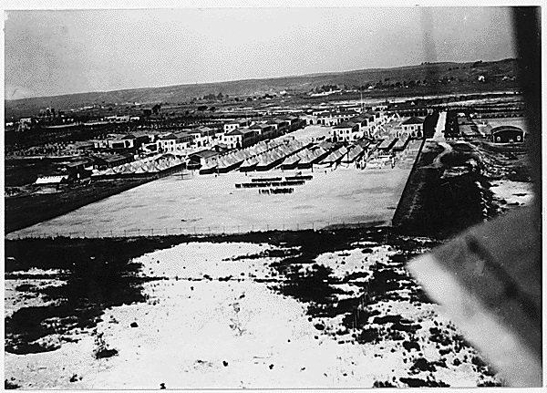
This series consists of color slides depicting various activities, places, and people at the Naval Training Center in San Diego, California. Images show recruit training activities such as: haircuts, clothing issues, physical training, swimming, activities on board the USS Recruit, fire fighting, and graduation. Buildings on the base are heavily documented and include images of the commissary, medical clinic, Navy Exchange, library, chapel, contact center, barracks, in-processing office, auditoriums, and other buildings. A small number of images show aerial views of the base, including views of walled tents in the "Detention" camp (also known as Camp Ingram) in 1923 and 1924. Images from 1983 document the activities that took place for the 60th anniversary of the Naval Training Center. Also included are slides from Governor Ronald Reagan's visit.
Record Group 326: Enewetak Atoll Photographs, ca. 1949 - ca. 1964
This series includes photographs and associated textual records generated by the Holmes & Narver Corporation relating to the construction of Atomic Energy Commission nuclear weapons test sites at the Enewetak Atoll. The photographs depict a variety of activities. Some relate to the construction of various scientific buildings, structures, and instruments, including, but not limited to: laboratories, weather stations and weather measuring devices, wind tunnels, high explosive dugouts, radar antenna, ground thermometers, and remote instruments placed in holes throughout the atoll. Others relate to the construction of buildings and infrastructure needed to sustain a large human population of contractors and government personnel on the various islands of the Enewetak Atoll, including, but not limited to: administration buildings, personnel quarters, roads, petroleum tanks, radio and telecommunication stations, power houses with electrical generators, desalination equipment, water and sewage lines, water towers, storage facilities, mess halls, recreation centers, shops, chapels, and hospitals. In addition, some of the photographs provide aerial views of the various islands and surrounding waters featuring buildings, camp areas, airstrips, boat piers, landing ships, barges, the lagoon at the center of the atoll, and large bomb craters. Further, some photographs depict day-to-day human activities on the islands such as office work, operating equipment, receiving supplies, recreation, preparing food, and medical visits. The vast majority of the photographs have control numbers, which can be cross-referenced with associated photograph lists in the files to ascertain photograph date and caption information.
Record Group 326: Jobsite Photographs of the Pacific Islands, ca. 1953 - ca. 1959
This series consists of photographic items pertaining to the construction and maintenance of Atomic Energy Commission facilities and infrastructure at the Enewetak Atoll, the Bikini Atoll, Johnston Island, Kiribati and other tropical islands in the Pacific Ocean. Most of the photographs show buildings and construction projects in different phases of completion including, but not limited to: administrative buildings, personnel quarters, storage facilities, electrical power stations, land and sea-based towers, shelters, revetments, roads, runways, piers, fuel tanks, water treatment buildings, water tanks, water and sewage lines, camp areas with tents, mess halls, kitchens, latrines, medical clinics, machine shops, outdoor theaters, aircraft hangars, balloon release stations, telecommunication buildings, radio antennas, and weather stations. In addition, many photographs feature vehicles and heavy equipment in-action such as barges, military ships, small boats, cranes, trucks, bulldozers, helicopters, airplanes, and seaplanes. Further, some items show aerial images of project sites, personnel engaged in work or leisure activities, tropical flora, and native islanders. This series is partially digitized.
Record Group 326: Photographs - Pacific Islands, ca. 1958 - ca. 1967
This series consists of photographs pertaining to the construction of buildings, facilities, and infrastructure needed to sustain Atomic Energy Commission operations on various tropical islands and atolls in the Pacific Ocean. The photographs depict a variety of scenes including, but not limited to: administrative buildings, personnel quarters, storage facilities, bunkers, revetments, beaches, roads, fuel tanks, water treatment equipment, water tanks, water and sewage lines, generators, telephone and electrical cables, camp areas with tents, mess halls, kitchens, barber shops, aircraft on runways, aircraft hangars, barges, piers, construction scaffolding, cranes, trucks, machinery, weather stations, balloon releases, rocket launchers, helicopters and landing pads, large computers, and telecommunications equipment such as satellite dishes and rotating antennas. Further, some photographs show aerial images of project sites while others show personnel engaged in work or leisure activities. The majority of the photographs relate to activities at Johnston Atoll covering the period February 4, 1962 through June 5, 1965.
Record Group 326: Project Photographs, ca. 1956 - ca. 1966
This series consists of black and white photographs and associated photograph indexes pertaining to the following Atomic Energy Commission nuclear test projects: Chariot, Cowboy, Dribble, Gnome, and Pinot. Most of the photographs in this series relate to Project Gnome, an underground nuclear test conducted near Carlsbad, New Mexico in December 1961. In addition, this series also contains a small number of photographs relating to Operations Hardtack and Redwing. The visual items depict a variety of scenes and activities including, but not limited to: surface and underground drilling, construction scaffolding, vent and access shafts, mine chambers intended for nuclear device detonations, neutron measuring pipes, tunnels, hydraulic jacks, lowering explosives into shafts, cementing mine walls, supporting mine pillars, conveyors moving excavated rock, pump and suction lines, water tanks, heavy equipment and machinery, trucks, cranes, local roads and ranches near the project sites, and project personnel camps and buildings. Further, some photographs show aerial images of the project sites while others show personnel engaged in work or leisure activities. The vast majority of the photographs have control numbers and some have descriptive captions written on their outer envelopes. Only Projects Dribble and Gnome have associated photograph indexes in the files with date and caption information listed therein.
Record Group 338: Aircraft Test Files, 1960 - 1990
This series consists of correspondence, memorandums, reports, news releases, publications, and photographs relating to U.S. Army aircraft testing as well as important milestones attained by personnel at the U.S. Army Aviation Engineering Flight Activity at Edwards Air Force Base in southern California. Topics covered in these materials included, but are not limited to: helicopter flight test performance; reliability testing of helicopter weapon systems; aircraft component design; cockpit instrumentation; test pilot training; aerial photography; honorary ceremonies and unit formations; and noteworthy piloting achievements of various personnel. Important aircraft referenced in these records include, but are not limited to: Lockheed AH-56A Cheyenne, Grumman OV-1 Mohawk, Boeing CH-47B Chinook, Bell AH-1G Huey Cobra, and Sikorsky S-67 Blackhawk.
Donated Materials: Photographs and Other Records Relating to Operation Crossroads, 1937 - 1997 (CMS-OC)
This series consists of photographs and textual records relating to Operation Crossroads compiled by Clyde M. Smith, administrative assistant to the Commanding Officer on Kwajalein. Locations depicted in the series include Honolulu, Hawaii; Wright Air Field, Ohio; Roswell, New Mexico; Tuzigoot National Monument, Arizona; Johnston Island Airfield; Bennett Island; Carlos Island; Majuro Island; Makin Island; Tarawa Island; and other islands that constitute the Marshall Islands: Bikini Atoll, Eniwetok Atoll, Kwajalein Atoll, and Rongerik Atoll. Photographs in this series show views of the base and its facilities on Kwajalein, natives of Bikini Atoll and the surrounding islands, cemeteries, aircraft, and other activities in preparation for the tests. One photograph (CMS-OC-1-11-37) depicts Dwight D. Eisenhower in his duty as U.S. Army Chief of Staff visiting the Kwajalein base. Photographs (CMS-OC-1-7-1 THRU CMS-OC-1-7-12) document the target fleet for the nuclear tests in Bikini Harbor. Aerial-obliques exist showing the USS Independence, USS New York, USS Salt Lake City, USS Shangri-La, and the Japanese battleship Nagato before the blasts. Photomechanical prints show Test Able in color. The finding aid for the series is available at NARA at Riverside.