![]()
Still Pictures Aerial Photography in Record Group 18: Records of the Army Air Forces
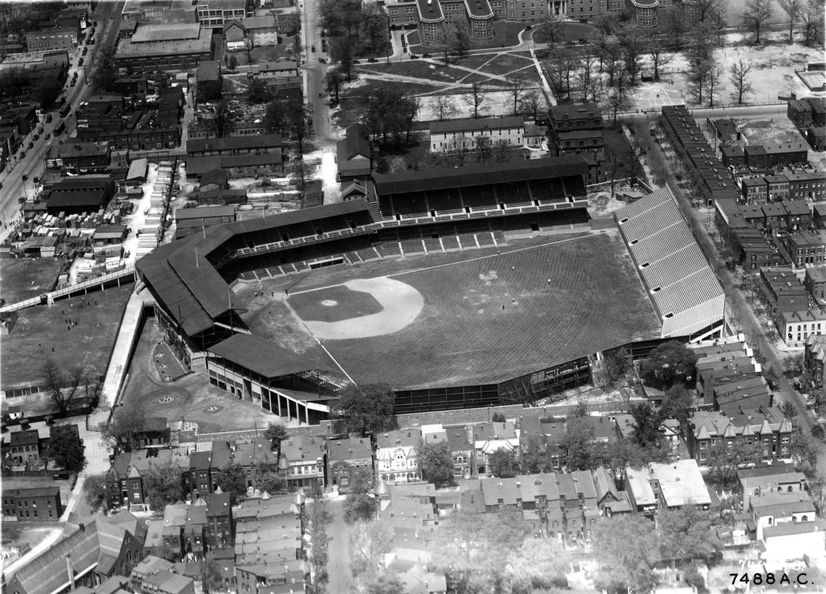
Aerial and Ground Photographs taken by Observation Squadrons at Langley Field, Va., Mitchell Field, NY., and an Unknown Field on the West Coast, 1925 - 1947 (18-LMU)
This series consists of ground, aerial oblique, and vertical photographs of municipal and military airfields, military bases, cities and historic landmarks along the east and west coasts of the United States and in selected states in the interior. Most of the photographs are of military airfields. The finding aid for the series is available in the Still Pictures Research Room.
Aerial Reconnaissance Photographs of France and Italy During World War II, ca. 1942 - ca. 1942 (18-AR)
This series consists of 195 aerial photographs taken of various areas and coastlines in France and Italy during World War II. The finding aid for the series is available in the Still Pictures Research Room.
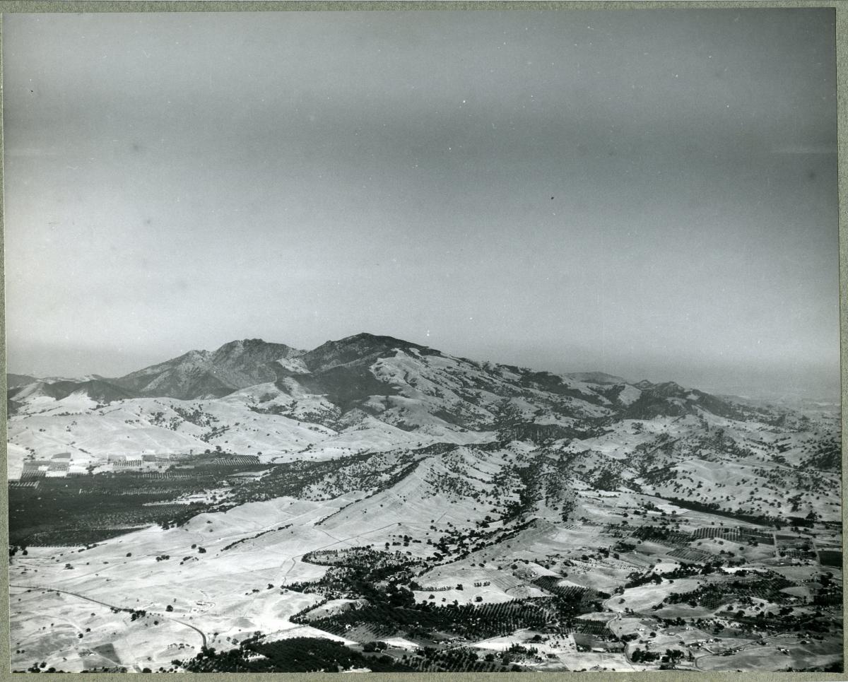
Aerial Survey of Scenic Landmarks in the Western United States, Photographed by Maj. Albert W. Stevens, ca. 1923 - 1929 (18-AL)
The photographs in this series comprise a part of some comprehensive aerial surveys of scenic landmarks throughout the Western United States undertaken by Albert W. Stevens in the 1920's. The photographs consist primarily of views of mountains and valleys throughout the West, including several views of cities.
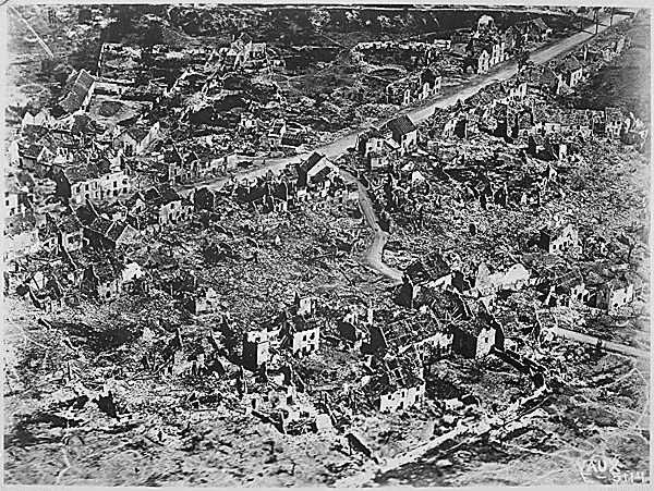
After Battle Pictorial Reports Relating to Cantigny and Chateau-Thierry, ca. 5/1918 - ca. 3/1919 (18-AB)
This series contains aerial, aerial-oblique, and ground photographs of the taking of Cantigny, France by the 28th Infantry Regiment, 1st Division, U.S. Army on May 28, 1918, as well as the holding of the Chateau Thierry, France sector by the 1st Corps, U.S. Army in July 1918. The series also contains textual and map interpretations documenting the movement of troops and supplies. Photographs include towns, cities, battlefields and activities in and around them, and personnel. This series is fully digitized.

Aircraft, Activities and Personnel at Rockwell Field, San Diego, (Erikson Collection), 1914 - 1918 (18-HE)
These photographs, taken by H.A. Erickson and Harold A. Taylor of San Diego and Coronado, California, were purchased by the Air Corps in 1941 for $3,000 because of their importance to students of military aviation. Included are aircraft on the ground and in the air, buildings at the field, repair shops, and personnel, many shown seated in or standing beside aircraft. Among the notables are Henry H. Arnold, Oscar Brindley, Glenn Curtiss, Katherine Stinson, Lincoln Beachey, Igor Sikorsky and members of the Aero Club of America. There are a few detail views of aircraft engines and cockpits. The series includes an aerial photograph of San Diego (18-HE-451). The finding aid for the series is available in the Still Pictures Research Room.
"Airscapes" of American and Foreign Areas, 1917 - 1964 (18-AA)
This series consists of aerial oblique, perpendicular, and some ground level photographs made or collected by the Aeronautical Division of the Signal Corps, the Air Service, the Air Corps, the Army Air Forces, and/or the USAF, showing prominent geographic and terrain features, cities, buildings, national shrines, historic areas, parades, earthquakes and flood disaster areas, airfields, and ports in the U.S. and abroad. Most photographs are captioned. The bulk is dated 1923 through 1945. A shelf list (Shelf list to Series 18-AA and 18-AN ("Airscapes" of American and Foreign Areas), ca. 1945 - ca. 1945 [18-AHAS]) and a finding aid for the series are available in the Still Pictures Research Room. This series is fully digitized.
"Airscapes" of American and Foreign Areas, 1917 - 1964 (18-AN)
These negatives correspond with 18-AA prints. Aerial oblique, perpendicular, and some ground level photographs made or collected by the Aeronautical Division of the Signal Corps, the Air Service, the Air Corps, the Army Air Forces, and/or the USAF, showing prominent geographic and terrain features, cities, buildings, national shrines, historic areas, parades, earthquakes and flood disaster areas, airfields, and ports in the U.S. and abroad. Most photographs are captioned. The bulk is dated 1923 through 1945. A shelf list (Shelf list to Series 18-AA and 18-AN ("Airscapes" of American and Foreign Areas), ca. 1945 - ca. 1945 [18-AHAS]) and a finding aid for the series are available in the Still Picture Research Room.

Air Transport Command Photographs, 1943 - 1945 (18-ZC)
Aerial photographs of airports and landing fields in the Belgian Congo, the Union of South Africa, Rhodesia, French Equatorial Africa, Tanganyika, Uganda, Ethiopia, Ghana, and India.
Aviation History, ca. 1903 - ca. 1927 (18-AH)
Lantern slides derived from, among others, Signal Corps negatives, Air Service negatives, and Dayton negatives (18-WP), covering all phases of aviation, including the Wright Brothers' flight at Kitty Hawk, the Alaska Flight of 1920, bombing of the USS Alabama and the Ostfriedland, aerial photographs of US and foreign cities, US and foreign aircraft, airships and balloons, and other aircraft components, and such personalities as Douglass Campbell, Thomas A. Edison, Billy Mitchell and Eddie Rickenbacker. The finding aid for the series is available in the Still Pictures Research Room.
Early Construction Photographs of March Field, California, 1928 - 1934 (18-MFC)
March Field in Riverside, California was established during World War I as an Air Service pilot training school. The photographs in this series date from a later period and document the various construction activities undertaken at the field between 1928 and 1934. The finding aid for the series is available in the Still Pictures Research Room.
Photographs of Aerial Views taken by the Air Force Command, 1943 - 1945 (18-AO)
This series consists of aerial photographs taken along the routes flown over the United States, the Caribbean, South America, islands in the Atlantic, Africa, the Middle East, the Indian Subcontinent, Asia, the South Pacific, Alaska and Canada. Also shown are ATO airports, emergency landing fields, mountains, glaciers, lakes, rivers, cities and towns, farming areas, and other terrain features. This series is partially digitized.
Photographic Prints of Denver and of Rocky Mountain National Park, Colorado, 1925 (18-CD)
This series consists of aerial oblique views of areas in and around Denver, Colorado and Rocky Mountain National Park, taken by Albert W. Stevens during his aerial photographic flights in the western United States in 1925. All of these photographs appear to have been taken at a relatively low level, perhaps 5,000 feet. Included are views of towns, farms, and Long's Peak in Rocky Mountain Park. Captions for all of the images are identical.
Photographic Prints of Glacier National Park, Montana, ca. 1925 (18-GP)
This series consists of aerial views of the area comprising Glacier National Park in Montana. They were possibly taken during Maj. Albert W. Stevens' aerial photographic survey of the western United States in 1925. Included are views of Bowman Lake, Kintla Lake and Kintla Peak, Starvation Ridge, Parke Peak, Heaven's Peak, and the surrounding countryside. All photographs are captioned.
Photographs of Activities of the 15th Photographic Section, U.S. Army Air Service, in France and the United States, 1917 - 1919 (18-PS)
These photographs consist of views of activities of the 15th Photographic Section in France during World War I. They were taken by 15th Photographic Section photographers, and show views of the Section's headquarters, laboratory and barracks in Neufchateau; personnel of the Section; vehicles used by the Section, such as motorcycles, cars, and mobile laboratories; and Allied and captured German aircraft. Also in this series are aerial views of France, including Paris, the Seine River, Montfrucon, Avocourt, and Montmedy. Battle areas such as Belleau Wood, the Hindenburg Line, and Bellicourt are also pictured. Views of damaged towns are also featured, with Apremont, Loupmont, Tours, and Verdun represented. The finding aid for the series is available in the Still Pictures Research Room.
Photographs of the Activities of Maj. Albert W. Stevens, ca. 1925 - 1937 (18-AWS)
These photographs document the many and varied activities of Maj. Albert W. Stevens (1886-1949), who is best known for his early and long involvement with aerial photography and high-altitude flights for the Army Air Corps. Stevens began his career in World War I, where he photographed from the air all of the areas in France in which American troops were active. His photographs proved of immeasurable value in cartographic work for the U.S. Army. After the war Stevens was assigned to McCook Field, where he continued his work on aerial photography, working to refine cameras and film, and conducting aerial mapping surveys. In 1923, 1925, and 1929, Stevens undertook extensive aerial surveys of scenic landmarks, National Parks, mountains and rivers throughout the Western United States. Several of his photographs were used in the July, 1924 issue of National Geographic. The finding aid for the series is available in the Still Pictures Research Room. This series is partially digitized.

Photographs made by the Photographic Section, Air Service, AEF, in France and Germany, ca. 3/1918 - ca. 11/1918 (18-E)
This series contains aerial, aerial-oblique and ground photographs primarily in France of towns, cities, battlefields, such U.S. Air Service facilities as air fields, airplanes, building exteriors and interiors and activities in and around them, and personnel (group and single informal portraits). Included also are some aerial and ground views in Germany in 1919 of cities along the Rhine, AEC outposts, airfields and personnel. The finding aid for the series is available in the Still Pictures Research Room. This series is partially digitized.
Photographs taken by Photo Squadrons Stationed at Scott Field, IL, ca. 1923 - ca. 1939 (18-SF)
Aerial (vertical and oblique) and ground-level photographs taken by the 15th and 21st Photo Squadrons of terrain features, cities, towns, agricultural areas, military bases and airfields and airports in Florida, Illinois, Indiana, Kentucky, Michigan, Missouri and Wisconsin. Many of the photographs are of the 1927 Mississippi River Flood and the 1937 Ohio River Flood. Approximately 60% of the photographs are of Scott Field, which was the center for military lighter-than-air training. Included are views of buildings and equipment, hangers, aircraft and airships and their support and maintenance operations, balloons, and aviators. The finding aid for the series is available in the Still Pictures Research Room.
Photographs of US Army Air Service Balloon and Equipment, 1908 - 1920 (18-MA)
Balloon and airship support facilities, airship components including inflation and equipment, maneuvering and guidance hardware, and instrument board; Type "R" balloon, and the first flight of the Type "C" Airship (C-1) in 1920; buildings and recreational activities at Ft. Crook, Neb.; a map of Camp Eustis, Va.; barracks and other buildings at Ft. Sill, Okla., 1918; aerial photographs of convoys, camps, and Scofield Barracks, TH, 1920 (filed under "Luke Field"); and servicing buildings, balloons, and balloon races at Ft. Omaha, Neb., 1908-1920. No AEC activities are documented. The finding aid for the series is available in the Still Pictures Research Room. This series is partially digitized.