![]()
Still Pictures Aerial Photography in Record Group 26: Records of the U.S. Coast Guard
Coast Guard Lifeboat Stations, 1893 - 1974 (26-CGS)
The Coast Guard maintains several hundred stations at dangerous points along the coast for the purpose of saving lives and property especially of shipwreck victims. This collection show most of the stations and their boats and lifesaving navigational aids. There are aerial views of the boat station buildings showing the layouts and access roads, launching ways, wharves, lights, repair shops, and living quarters of the assigned crews. Some of the stations shown have aircraft and larger motor boats. There are a few views of floating stations and of personnel.
Lighthouses, 1855 - 1933 (26-LG)
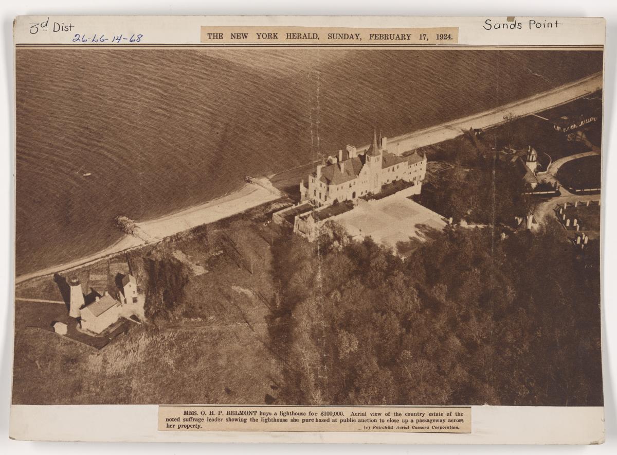
Lighthouses, aids to navigation and miscellany created for and or by the Lighthouse Service and its predecessor agencies. Photographs show views of the structures, surrounding areas, shorelines, and depict the living conditions of keepers, their families and of maintenance personnel. There are views showing construction of the buildings and installation of lights (including Sabine Bank, Texas in 1904); light structures at forts and at Alcatraz Island in California; memorial lights, lightships; and portraits of keepers (box 69). Most of the photographs are black and white and cyanotypes scattered throughout. They vary in size and most are mounted on cards. Some of the original prints are fading and the mount cards are worn and fragile. Notable lighthouses are Cape Hatteras in District 5, Sandy Hook in the 3rd District and the Tybee Island Light in the 6th District. Photographs of miscellaneous and foreign lighthouses are in boxes 69 through 71A. The series includes an aerial photograph of Sands Point, New York (26-LG-14a-68). The finding aid for the series is available in the Still Pictures Research Room. This series is fully digitized.
Lightships, 1891 - 1935 (26-LSON)
Prints and negatives of lightships and lighthouse tenders that served under the Lighthouse Service. They are shown underway, at work with crews and lighthouse keepers and in drydock for repairs. Shown also are lights, lamps, buoys, charts and diagrams, and a few aerial views. Some of the lightships and lighthouse tenders shown are- Hens and Chickens, Diamond Shoal, Stone Horse, Jasmine, Nantucket Shoal, Umatilla Reef, and the Tulip. Some of the prints are mounted and appear to have come from an album. Contact prints made from loose negatives found in the original print box show construction of unidentified lighthouses. Negatives and prints of the lightships do not necessarily match. Photographs of lightships are also in 26-LS. The finding aid for the series is available in the Still Pictures Research Room.
Photographs of Activities, Facilities, and Personalities, 1939 - 1967 (26-G)
his series consists of photographs documenting the history of the Coast Guard and predecessor agencies. Most of the photographs taken after World War II were created by one of the 17 Coast Guard districts and forwarded to headquarters. Within this series is a set of "Release" photographs, selected from the main body of photographs as the best or most topical images. These photographs were distributed most often to the media and controlled by a separate serial numbering system. The major subject of the collection is World War II combat, in the Atlantic and Pacific, including some famous views of the Normandy invasion. Other general subjects are aids to navigation, training, lifesaving and rescue operations; aviation; ice patrols; and, most numerously, ships and boats. More specialized subjects are early 20th century Alaska; Admiral Byrd's Antarctic Expedition, 1946-47; artwork; rum-running during Prohibition; the space program; and Cuban refugees. The finding aid for the series is available in the Still Pictures Research Room. This series is partially digitized.
Photographs of the Baffin Bay Iceberg Census, 1948 - 1948 (26-IIP)
This series consists of photographs taken during an aerial survey of icebergs by the International Ice Patrol during the 1948 season.
Photographs of Discontinued Lights and Stations, ca. 1900 - ca. 1972 (26-DS)
This series of black and white and color photographs show discontinued navigational aids such as minor lights, radio stations, LBS (lifeboat stations), LAS (Light Attendant Stations) LORAN, ELMOS (Emergency Loran Mobile Stations), and a few lighthouses. Also shown are construction views, weather related damage to the structures and surrounding areas, repair activities, fuel and water tanks, cable lines, storage facilities, beachfronts, aerial views, local people, and station crews. Photographs of an oil spill in St. Paul, Alaska in the 1970's are in folder 549. Represented are Coast Guard Districts 1 through 13, and 17 in folders 1 through 555. There is no folder number 26 in box 2. Boxes numbered 23 through 32 contain various size small prints taken of locations in district 13. The Coast Guard did not file them in separate folders by the stations, but rather grouped all aids or stations of the same alpha character in the same file. There are a small number of color transparencies, slides, and negatives dispersed throughout this series.
Photographs of Discontinued Lights and Stations in Foreign Locations and U.S. Territories, 1900 - 1972 (26-DSF)
This series of photographs show discontinued navigational aids located in some foreign countries and U.S. territories. Shown are minor lights, lifeboat stations, radio stations, LORAN (Long Range Navigation Stations), ELMOS (Emergency LORAN Mobile Stations), LBS (Lifeboat Stations), and a few lighthouses. Also shown are construction views and weather related damage to the structures and surrounding areas; repair scenes, fuel and water tanks, storage facilities, beach fronts, aerial views, natives, and Coast Guard personnel. Represented are districts 7, 10, and 14 in folders 1 through 257. The finding aid for the series is available in the Still Pictures Research Room.
Photographs of Discontinued Shore Units, 1945 - 1961 (26-LB)
Photographs taken by the Coast Guard showing lifeboat and light stations that are no longer in use. Views show lightboat stations in different areas throughout the United States, navy barracks, boathouses, docks, launchways, ships in dock, towers, rivers, creeks and the Federal Prison at Terminal Island. There are also photos of an aerial survey of storm damage to units on Assateague Island. The finding aid for the series is available in the Still Pictures Research Room.
Photographs of Greenland Survey Expeditions, 7/1940 - 11/1940 (26-H)
Photographs taken or acquired by the U.S. Coast Guard showing the USCGS Duane at sea, aerial views of Greenland icebergs, ice fields, docks, mines and mining camps, a cryolite mine in Ivigtut, Greenland, Godthaab waterfront, motor boats, glaciers, charts showing course taken on trip, rock formations, entrances to different harbors, channels, Mt. Kuanit, flatlands, islands, ships at dock, mountains, rivers and other miscellaneous views. There are also copies of letters, mission reports and surveys of ports in West Greenland. Most of the photographs are captioned. There are corresponding copy negatives. The finding aid for the series is available in the Still Pictures Research Room.
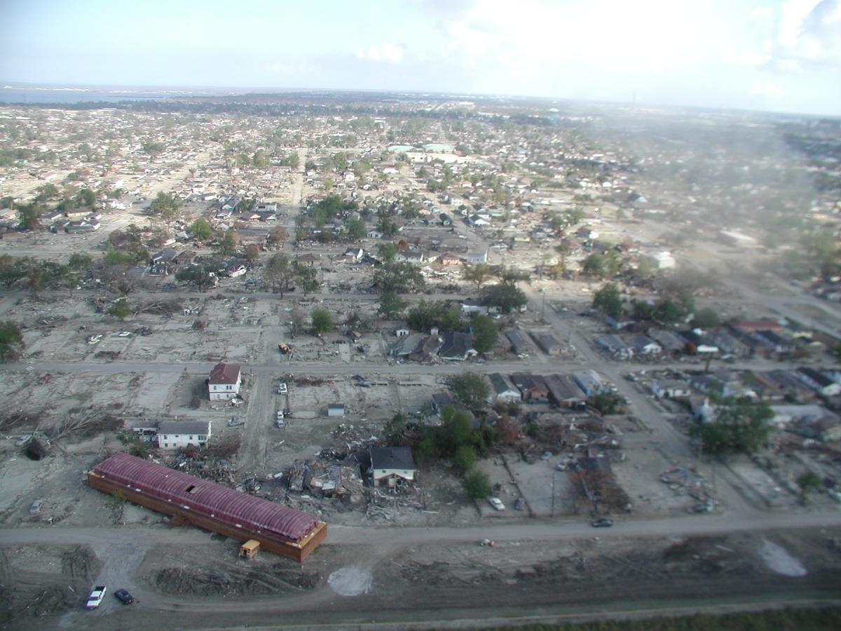
Photographs Related to Hurricane Katrina, 8/2005 - 1/2006 (26-HK)
Photographs in this series depict images related to Hurricane Katrina and its impact on the southern portion of the United States. Both aerial and on-the-ground photographs show the aftermath of the storm and the extensive destruction across large cities and small towns in Louisiana, Mississippi, Alabama, Texas, and Florida. Photographs show flooded streets, displaced boats, displaced vehicles, destroyed bridges, damaged buildings, damaged houses, large piles of debris, and other hurricane-related damage. Also pictured are stranded individuals, rescue operations, and other assistance programs to aid those affected by the storm. The finding aid for the series is available in the Still Pictures Research Room. This series if fully digitized.
Slide Shows Related to Hurricane Katrina, 8/2005 - 11/2005 (26-HKS)
Records in this series consist of slide shows related to Hurricane Katrina and Coast Guard operations. Many slide shows feature aerial and on-the-ground images of the hurricane damage as well as accompanying captions and annotations. In some instances, slide shows feature "before" and "after" photographs of the same location to emphasize the destruction of a particular area. Slide shows show various cities and small towns affected by the storm, with particular emphasis on New Orleans, Louisiana, Venice, Louisiana, and Biloxi, Mississippi. Slide shows also document a visit by President George W. Bush, vessel salvage and removal operations, rescue missions, and the clean-up process. While the majority of slide shows pertain to Hurricane Katrina, a small number of slide shows also have images and content related to Hurricane Rita. The finding aid for the series is available in the Still Pictures Research Room. This series if fully digitized.
Survey of Lighthouses, 1945 (26-S)
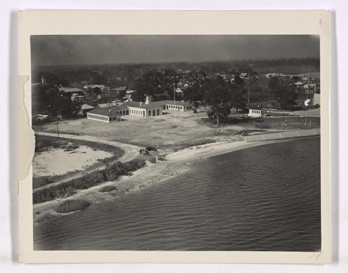
This collection of photographs was taken by the Coast Guard presumably as part of a survey of aids to navigation at various Coast Guard district locations. Most of the photographs which are aerial views, show types of structures, surrounding areas and the general appearance of the stations. There are views of radio beacons, generators, air compressors and engine rooms. Some of the lighthouse stations pictured show lifeboat houses, keeper's quarters, and other buildings. Also included are views of jetty lights, channel lights, fog signals and bells. Some of the lighthouse stations are Cape Flattery, Point No Point, Point Conception, Old Point Comfort, and Whitefish Point. This series is partially digitized.

Tours of United States Coast Guard Loran Stations, 1948 - 1953 (26-T)
The Coast Guard maintained a chain of Loran Stations in Alaska and in the Southwest Pacific to provide electronic navigational aid to ships and aircraft. These stations were serviced and supplied basically by PBYs and LCM boats from nearby military bases and were visited annually by the USCG cargo ship, Kukui (WAG-186) whose home base was Honolulu. Some of the stations were Cocos Island; Naula Point; Iwo Jima; Tarumpitao Point; Ichi Banare Island; and the Guam Island station. This collection documents those visits. Views depict landings; departures; loading and unloading supplies; aerials of stations and buildings; antennas; transmitters; water tanks; power rooms; miscellaneous operations and repair scenes. There are views of officers inspecting the Kukui while at sea; of a congressional inspection tour of the Loran stations by the House Appropriations Committee in 1952 and views of the Bataanes Philippine Islands Loran station of the Elmo project in 1953. Views of island natives and local personalities are throughout the collection. Most prints have negatives. The finding aid for the series is available in the Still Pictures Research Room.
United States Maritime Service, 1938 - 1941 (26-A)
Three albums of mounted prints depicting activities at several Maritime Service Stations and Coast Guard Stations. Photographs show Maritime Service enrollees in various training classes such as gunnery, sailing, signaling, navigation, diesel engine repairs and a few others. There are views of the enrollees at mess halls, dentists, barbershops, during muster and while at liberty. Some of the training stations pictured are at St. Petersburg, Florida; Fort Trumbull; Hoffmann Island, Hueneme, Gallups Island; Government Island, California; and a few taken in Boston, Massachusetts in 1942. Aerial views of the stations are included.